Tuesday, March 18, 2008

Clipper Update:


A clipper will come zipping through here Friday afternoon/night. It will spread with it mainly snow in the north and mixed precip or rain in southern Ohio. Sticking to 3-6" NW and north central Ohio, and 1-3" in far NE Ohio. Less amounts farther south. There will be some precipitation streaking into the NE US also. No major snows, but parts of southern New England could also see 3-6" or so of snow. Looks like surface temps will be a bit of an issue with this clipper so areas in mountains will see the best chance of heavier snow. A more detailed map tomorrow.

Monday, March 17, 2008

Sneaky Snowstorm Friday?

A moisture laden dynamic Alberta Clipper looks to be dropping through here on Friday, and we could have a little surprise snowstorm. There are two questions: Will this thing be suppressed to the south? and Will it be cold enough for snow? Well, the answer for both is kind of up in the air. But I think the clipper will be strong enough that it could creep north enough to give us moderate precipitation across Ohio. Most of the ensembles and all the operational models but the NAM (no surprise) show all of Ohio getting .4-.6" of QPF except extreme northern Ohio, but a lot of times I will watch clippers slowly get pushed south out of the area on models in the days leading up to them. And will there be enough cold air? In the north, probably cold enough for all snow. The rest of the state will see either rain or a rain snow mix as it stands now...so, when we put that all together what am I forecasting:

A clipper will provide moderate precipitation to most of Ohio, and only light precipitation to far northeast Ohio. North of a Findley-Akron-Youngstown line expect all snow and 3-6" in NW and north central Ohio with 1-4" in far northeast Ohio. Between that line and I-70 in south central Ohio expect a rain snow mix with slushy accumulations of a coating to an inch Friday evening/Night. South of I-70 expect mostly rain with no accumulations. I smell a snow map on this storm Wednesday or Thursday so stay tuned!

Snow Map

Well I hinted at it in my discussions earlier today and I believe there well be some snow after the storm across Ohio. 1-2" for most of the state but 3-5" in the Snow Belt where the lake can enhance totals a bit. Over northern New England where they will not go over to rain they could see over a foot.

Eastern US Weather Discussion

High pressure is in control up and down the east coast at the moment with no significant weather to speak of over the next day or so. But the East will not be spared from the flooding and severe threat the upcoming storm poses. There also will be a wintry side to the storm over northern New England. After a chilly start tomorrow morning in New England most of the day tomorrow will be fairly nice in the east. Temps will go up to near or slightly above normal out ahead of the storm system that will be affecting the region this week. High pressure will slide east off the coast tomorrow, and rain will break out across PA, NY, and the upper Mid Atlantic tomorrow afternoon out ahead of a warm front. The southeast US and New England will remain dry tomorrow during the day as high pressure will still be keeping these areas dry. Tomorrow night the rain will continue spreading NE into New England but amounts should be under 1" so no major flooding yet although areas in PA where snow melt and moderate rain amounts there could be some nuisance flooding breaking out. The precip over northern New England may fall in the form of snow, but nothing too heavy yet. The SE US will remain mainly dry tomorrow night with just some isolated thunderstorms possible in the warm air mass. Wednesday the severe weather, flooding rain, and chance for a winter storm will materialize across the eastern portion of the country. The cold front will start crashing into the SE and areas like Alabama, Georgia, the Carolinas, and up into the Virginias/DC region there will be a severe weather threat. Right now I do not for see a huge tornado outbreak but there will definetly be a squall line coming through with a chance of isolated super cells out ahead of it. Areas in the Mid Atlantic will continue seeing periods of moderate rain and river levels will start to rise some. Wednesday night the cold front will continue east and a lot of the east will continue to dry out. I do not see much more than nuisance flooding except for in PA where heavier rain will fall and over southern New England where snow melt will compound any flooding problems. As colder air slips in and the storm really wraps up northern Maine, Vermont, and New Hampshire will see a major snow storm and 7-14" of snow may fall along with gusty winds. A snow map for this will definetly be issued tomorrow. The east is also watching for a potential snow storm next Monday/Tuesday, but the models are currently keeping the storm will south of the Mid-Atlantic and New England and only shows light rain over the south, but as I have said before this could very well change.'

Ohio Weather Disscusion

Well, in terms of flooding and severe weather nothing changes from my thoughts yesterday. There will be a severe weather outbreak mainly in the south, with tornadoes and high winds being the biggest threats, but I do not think this will be an extremely large outbreak in which the SPC puts out a high risk. I still think there will be flooding problems from Texas through the lower Great Lakes, and nuisance flooding all the way into New England. Wednesday afternoon/night we will transition to snow across Ohio. Right now I think most of Ohio will see 1-2" of snow, and the Snow Belt will see 3-5". Those are up from earlier because the models are indicating some deformation snows across Ohio Wednesday evening. Right now I am a bit skeptical about it, so I am sticking to the lower accumulations. But, if things change I may need to issue a snow map for this tomorrow or Wednesday. Thursday there will be lingering lake effect snow showers in the Snow Belt, but accumulations will be minimal. Friday and Saturday will be tranquil. Sunday and Monday there is still a chance of major snow, but today all the models have gone south with the storm and leaving us mainly dry, but of coarse things could change and I will continue to monitor the situation the rest of this week.

Sunday, March 16, 2008

More Hype: Major Snowstorm Still POSSIBLE Around Easter


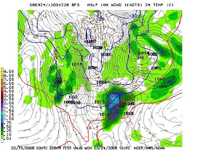
Well, another model run this afternoon just added to the already growing excitement over a possible snowstorm around easter or the day after. The EURO, the top image is very similar to what the 12z GFS looked like, showing a strong area of low pressure tracking just inland from the Atlantic ocean all the way up the east coast. That would mean heavy snow for us. The 18z DGEX also looked a lot like the 12Z GFS and EURO, showing a low tracking just inland from the Atlantic Ocean up the east coast. It showed snow from northern Ohio with mixing or rain for central/southern Ohio. The 18z GFS tracked farther SE, missing us with the heaviest snow. As of now this storm is very hard to call, as we could still see anything from mainly rain across Ohio to a blizzard to hardly anything, but as it stands now, the possibility is there from the Great Plains through Ohio, and the rest of the lower Great Lakes, and into New England of a major late season snowstorm. Right now I think that unless the low is suppressed way to the south most of the big cities along the east coast (except for Boston) will see mainly rain, but it is areas not too far inland that are higher up that need to watch for heavy snow in the NE, and through New England as well. Much more on this later.

Very Rainy and Stormy in the East


As I have been saying all weekend, we will definetly be seeing a spring like storm this week, with warmer, more humid air, heavy, flooding rains, and severe weather especially in the south. IMO this will not be a HUGE severe weather outbreak, but will be decent, with damaging winds and tornadoes being the biggest severe aspects, although any strong storm may pack hail with it. The severe weather outbreak will be fueled by cold, winter like air crashing into spring like warm air, and the strong jet stream energy associated with the cold front adding the threat for strong winds and tornadoes. This will not be as large an outbreak as we have seen a couple times this winter, because the air behind the front will not be as cold so there will be less instability, and the jet stream energy won't be as extreme but as I said earlier we still will need to watch out for a moderate sized severe weather outbreak. Another major concern is flooding, as the cold front will be moving rather slowly with waves of low pressure riding along it, so areas could see an extended period of heavy rain. We will have to watch a corridor from Texas all the way into the lower Great Lakes for the potential of 3-6" of RAIN, on top of already saturated ground. That always spells trouble. So, stay tuned on this one as we could be talking about severe weather and major flooding over the next few days.

Hype: More on the Powerhouse Storm I Mentioned Earlier


Well, the 12z GFS is back in LaLa land...It is showing a cold snow storm for use next Sunday and Monday. So is the CMC...however the EURO, DGEX, and other runs of the GFS are showing a warm rainstorm with severe weather. Right now, I am not willing to pick a side as we are still a week away from this storm impacting us. But either way, it looks like east coast snow lovers are probably not going to see a large Nor'Easter snow storm, but areas from the Apps and New England and points NW do need to watch for a POTENTIAL snow storm.

Severe in the South, Flooding Everywhere


As I said yesterday we are in for a lot of rain in the eastern half of the country Monday-Wednesday, and severe weather in the south. Why? A cold front will drift southeast across the eastern portion of the country. As that is happening, several waves of low pressure will ride up the front, adding more energy and slowing down the front. The slow speed of the front and abundant tropical moisture will cause an extended threat of heavy rain ahead of the cold front. Near the cold front there will be more instability due to the clash of air masses and jet stream energy. This will cause a severe weather outbreak, especially in the south as there will be more instability there due to warmer air and higher dew points. As I said yesterday there won't be much of a wintry side of the storm, but behind the cold front on Thursday there could be some lake effect snow, but right now I don't see more than 1-4" of snow piling up in the Snow Belt Thursday/Thursday night. There could be another power house storm late next weekend and early next week but there are questions if we will see a lot of snow or a lot of rain, but right now I am leaning towards the latter as we are quickly coming up on April and winter's days appear to be numbered, but either way stay tuned as it could still have negative impacts on our weather because even if it is warm flooding could be an issue.

Saturday, March 15, 2008

Another Week, Another Storm!

It is getting close to spring in the Northern Hemesphere, and this week we will experience some spring weather Tuesday/Wednesday. A storm will track from Texas and right over us, pulling in a lot of tropical air. This will result in showers and thunderstorms breaking out from the Gulf Coast all the way up into New England. There could be an extended period of heavy rain here in Ohio, and we could see some flooding problems as the ground is already saturated. There is also a severe side to this system. I think it will be confined to the south, because that is where the most instability will be. This could be another tornado outbreak because there will be a strong jet stream and a lot of shear interacting with the instability in the south. Here in Ohio, there will be much less of a severe threat but there will still be some vigerous winds aloft so we could see some gusty thunderstorms especially if we get a break in the rain and the sun comes out. As of now it appears there will not be a major snowstorm with this even on the northern frindges because there will be a lot of warm air in place, thus the threat for heavy rain and flooding. We will have some lake effect behind this storm on Thursday, but not more than 1-4" in the Snow Belt as there will not be extremely cold air in place. Stay tuned as we could see some major flooding problems.

Hype: Spring Snow Storm?

Are we in for another major spring snow storm? The GFS says yes! It appears there is a chance for another 6"+ snow storm for a lot of Ohio near or slightly after easter, with lake effect behind the main storm. The GFS is the only model that goes out this far, but the DGEX is hinting at a major storm developing at the end of its run. Another update later.

Friday, March 14, 2008

The Boy Who Cried Snow

Well, I still am not certain about it, the storm may try to come a little farther north, but it appears the storm will take the southern, more suppressed track...The high pressure coming in from the north appears to be stronger than originally expected and the SE ridge is not re-developing strong enough to keep this storm north...I guess I can't outsmart the NWS very often each year, and this was no different...they stayed with the logical forecast, and that hasn't always worked for them this year, but in this case it was the right thing to do. So, what will fall (or not fall) on our heads tomorrow? Well, in Northern Ohio some sprinkles and flurries. In central or southern Ohio, we will see a period of rain in the afternoon changing to snow showers tomorrow evening, adding up to a coating to an inch down there. Sunday morning there could be some lake effect snow but don't expect anything heavy, just flurries and a couple of snow showers, and the chances are that are even kinda low...

Thursday, March 13, 2008

Some Fresh Snow


The models are still not in good agreement, but as I said in my post on Tuesday I think northern Ohio will see a few inches of snow, with some rain mixing in farther south. Now I mentioned the models...a lot of them are indicating a storm that will stay suppressed and farther south, and keep us dry, but I don't see that happening. Here is why:

1. A tight temp gradient, strong jst stream, and abondant moisture will cause the storm to become pretty potent...stronger storms move more to the north as storms bring warm air north from the equator...

2. No overwhelmingly strong high pressure north of the storm. Even if the storm is a bit weak, I see no high pressure to sufacate the storm and keep it to the south.

3. South East ridge...OK, it will be off the SE coast, but will bump the storm northward, especially since there is no strong high pressure north of the storm...

So, what does that all mean to us? Well, in northern Ohio, expect a period of light to moderate snow Saturday/Saturday night...it will not amount to anything huge, but 1-3" along the lake shore with 3-6" inland is a good estimate. But, in southern Ohio, the air will be too warm for an all snow event...south of a Youngstown-Canton-Mansfield line the precip will start as rain on Saturday, and end on snow Saturday evening, leaving 1-2" of snow for southern Ohio. Bottom line is this is not a huge storm, but the media and NWS are overlooking it a bit because over half the models are not giving Ohio much snow, but, for the reasons listed above, I think the smaller portion of models showing some snow for Ohio will be correct. Another update tomorrow...

Tuesday, March 11, 2008

Another Snowstorm?

Could Ohio be in for another major winter storm? Well, maybe. It looks like a low pressure system will track just south of Ohio Saturday, and that COULD bring in some more significant snow, mainly to northern Ohio. However, the storm will not be particularly large or cold when it passes south of us, so there are a couple of major forecast questions:
1. Will the precipitation be rain or snow? In northern Ohio, I think yes, most of the precip will be snow. But, for the southern 70% of the state it will either be a rain/snow mix or rain.
2. Will the heavy precipitation make it into the cold air? At this point that is yet to be determined. It looks like there will be some moderate precipitation making it into northern Ohio, and maybe to the Lake Erie shoreline.

So, my forecast: A stripe of 4-8" of snow somewhere between central Ohio and Lake Erie, with rain to the south and much less snow to the north. Stay tuned, as this forecast could change because we are still several days away. This kind of reminds me of the 2007 Valentines Day Storm, where it looked like we would see light mixed precipitation up until 2-3 days before the storm, when models suddenly showed heavy snow for northern Ohio. I don't think this will be a repeat, but as I said 4-8" of snow is definitely in parts of Northern Ohio.

Monday, March 10, 2008

Forecast


Sunday, March 9, 2008

Some Time to dig Out!

As you can see in the Cleveland area 7-day forecast we can put the shovels away for the up coming work week! We may see some flurries tomorrow and maybe a dusting of snow Tuesday night but nothing shovel able until Saturday at the earliest!

Saturday, March 8, 2008

Blizzard of '08 Under Way!


This evenings rush hour was a mess all across Ohio. Some dryer air has intruded into the SE portion of the state but everywhere else we have been seeing moderate snow all evening. Generally 2-6" of snow across Ohio so far with blowing and drifting. But tomorrow will be the worst part of the storm, as we will see very heavy snow and high winds, which will create blizzard conditions. There is even a Blizzard Watch of Warning for all of Ohio except SE Ohio and far NW Ohio. I am going for another 2-5" of snow tonight across Ohio (after 12AM) with less possible far SE as there will be some mixing. Then tomorrow it looks like 4-8" of new snow with wind across the vast majority of Ohio. Most of Ohio will see storm totals of 10-16"+. The snow maps are for total snowfall and I made them Thursday, but didn't get time to post them.

Wednesday, March 5, 2008

Another BIG Storm!


As northern Ohio continues to recover from yesterday's major ice storm, another major snowstorm is waiting to come in. Looks like mainly snow with 1-4" in extreme NW Ohio, and 4-8" in SE Ohio with some mixing, and the jackpot of possibly over 12" of snow over NE Ohio. This storm is not lake effect, so everyone will have an equal oppertunity of HEAVY snow and even some high winds on Saturday. It looks like SE Ohio could see some sleet/freezing rain mixed in Friday afternoon which will cut down on accumulations. As of now, it looks like moderate to heavy snow will spread across Ohio during Friday morning, continue through Friday afternoon, and Friday night. Saturday the snow will taper off in western Ohio, but as the main low passes by eastern Ohio will continue to see heavy snow and the winds will pick up, leading to near blizzard conditions. I expect anything leftover Saturday night to be flurries. This event will not be a quick hitter and will last around 24 hours in the west and as long as 36 hours in the east. This could be the biggest widespread snow event in the winter, so stay tuned! As of this evening there were still close to 40,000 people still in the dark due to yesterday's ice storm.

Sunday, March 2, 2008

MAJOR ICE STORM ON THE WAY

Northern and Northwestern Ohio are under the gun for the largest ice storm in the last couple of years. Late Monday night and Tuesday morning expect a period of very heavy freezing rain and sleet across northern Ohio. In NW Ohio this will be more sleet and snow than freezing rain, and several inches could fall. In northcentral and NE Ohio it will be more freezing rain and sleet, and trees and power lines could have over a half inch of ice accumulate on them, so there will be quite a few power outages. Tuesday afternoon the precipitation will become more scattered, but some additional icing problems are possible. Tuesday evening into Tuesday night we will see a period of precipitation that will likily start as sleet/freezing rain and end as snow overnight Tuesday, with light accumulations. This ice could have many negative impacts so stay tuned!