Saturday, July 26, 2008

August Outlooks


Note: These are my first attempt at long range forecasting. They are highly experimental, and I am trying these to see if I have any skill in long range forecasting, and if I will be making these maps monthly.
Discussion:
During the month of August, it appears that there will be a large ridge over the western US, and an occasional trough trying to dip down over the GLs/NE. It appears that from time to time, the ridge in the west may try to build east for a couple days, but nothing persistent. In the west, there will be a dry SW flow on the west side of the ridge. I have put the coast in slightly lower temps than the rest of the west due to the cooling effects of the Pacific. However, in the rest of the west, under the ridge and with a SW flow, it looks like it will be warm and fairly dry. So, I put much of the inter mountain west in above normal and fairly dry conditions. In the extreme NW, a trough may be trying to build down, so I added normal precip and near normal temps. In parts of the SW, I did not go crazy with temps and added in normal (may end up busting a little above) precip, due to the monsoonal flow. Now, you may be wondering why there is a large area of below normal on the edge of the heat ridge and well above normal precip. Well, it looks like it will be quite stormy on the northern edge of the ridge, as it usually is. Which is why I put in below normal temps and above normal precip in that area. The above normal precip I have fairly high confidence in. However, I am a little concerned that the temps may end up being closer to average instead of below average in that area, due to warmer night time minimums, even if day time maximums are below normal. In the south central states, I put in above normal temps and below normal precip. The flow around the high the majority of the time will be out of the NW, which is a fairly dry flow, so I expect fairly dry conditions in that area with above normal temps. In the NE, I added above normal precip and put in above normal temps for most of the NE, but with a small area of cooler weather noted closer to the Canadian border. This is because a trough will be effecting the area from time to time, which easily agrees with the above normal precip. However, why did I put in above normal temps? A few reasons...one of the big reasons is despite the troughiness for the majority of the summer, temps have been normal to above normal in the NE, mainly due to nighttime lows being warm. Although I really have no reason to explain it, this reason made me lean against below normal temps. Another reason is, the heat ridge may try to build east from time to time, causing above normal temps as that happens. The third reason...which may just by me going out on a limb...the models are hinting that the trough axis may try to setup a little farther west...over Ontario/the northern GLs...opposed to Quebec...this would put the NE US in a warm, moist SE flow ahead of the trough. So, on a perhaps slightly shaky decision, I went with above normal in much of the NE/Mid Atlantic for these reasons. NOTE: I CAN SEE HOW THIS CAN LEAD TO A BOUT OF MAJOR HEAT IN THE EAST. And in the SE I went with above normal temps and normal precip because the ridge will extend east into the SE.

Tuesday, July 22, 2008

Dolly Update: Dolly Still Threat to Western Gulf


Note: 12z=8AM EDT...0z=8PM EDT
Discussion:
Dolly's interaction with the Yucatan, although brief really disrupted the circulation last night, so Dolly has spent all of today trying to develop an inner core, so it really hasn't strengthened yet. However, it looks like a small inner core has formed, and now an "eyewall" is trying to form, although up to this point it isn't very pretty yet. The reason the system is having a tough time wrapping deep convection all the way around the center is because of dry air off to the SE of the COC. However, it appears that Dolly will be moving away from the dry air, which should help convection wrap all the way around the center. Right now, outflow is good in all quadrants except the S/SE quadrant, where some dry air is getting pulled into the system. Also, wind shear is very low and is expected to remain that way. Also, oceanic heat content is moderately favorable for intensification in Dolly's path over the next day. So, over the next day, once Dolly can wrap that "eyewall" all the way around the center, I see no reason while a modest to fairly quick strengthening won't occur. After that, all factors will remain favorable for intensification, except for oceanic heat content which will become a little less favorable for intensification. It will not cause a weakening in Dolly, but will slow strengthening. This little "cooler eddy" of water as described by the NHC may save the western Gulf coast from a major hurricane, but again with modest to good conditions for strengthening over the next 36 hours while it is over water, I believe a CAT 1 hurricane will easily be reached, if not a CAT 2. (less bullish than yesterday, due to inner core taking longer to get organized) Now that you know the reasoning for the intensity forecast, here is the reasoning for the track:
The reasoning for track is similar to yesterday, but with a more westerly movement than expected today, the track has been shifted slightly to the left. Currently, a ridge is keeping Dolly on more of a westerly track rather than a NWerly track. However, this ridge is expected to break down over the next day and allow Dolly to move more WNW. The ridge breaking down will also cause Dolly to slow down some over the next day. However on Wednesday as Dolly approaches landfall, a ridge will start building to the north of Dolly. This will nudge Dolly more to the west again just before landfall. Right now, this solution is supported greatly by all models, as there is a very tight model consensus for both track and speed. Landfall looks to be very near the TX/MX border. This could pose a threat to the Brownsville area which is fairly heavily populated.
Forecast intensities:
12z Tue: 55 knots
0z Wed: 65 knots
12z Wed: 80 knots
0z Thu: 50 knots
Landfall intensity: 85 knots (~97MPH)
Not as bullish as yesterday, due to the Yucatan disrupting the circulation more than expected (not surprising, given that it was a developing cyclone), but you can't blame me for being a little bullish at first, because all the factors were/are there for intensification, but the center took a while after getting back out over water to organize. Still, far southern TX/northern MX need to prepare for a storm surge of 4-7', power outages, and perhaps some structural damage, especially to mobile homes.
NOTE: Some of the links are time sensitive, and I wrote this around midnight. I believe the NHC link, dry air link, shear link, and model link are all time sensitive, so they may not look exactly the way they did when I wrote this discussion.

Monday, July 21, 2008

HURRICANE ALERT: DOLLY POSES MAJOR THREAT TO WEST GULF COAST


Right now, all other weather issues will have to be put to side, because this will probably dwarf all of them. All things are pointing to a strong hurricane moving through the western Gulf and into the southern Texas coast. This storm will make Cristobal look like a puff of wind and a squirt of rain. Based on radar and satellite imagery, it is clear that Dolly's center has relocated to just WSW of Cancun. Also based on radar and satellite imagery, it is over the southern area of deep convection, and is rapidly organizing. Also, with the re-location, the center will just graze the Yucatan, so strengthening will not be inhibited at all until landfall on Wednesday.
Full discussion/reasoning:
With the relocation of Dolly, I went north of 0z guidance. But, over the next 48 hours, Dolly will follow the flow around a high pressure over the southern US/northern Gulf. It appears the ridge will be braking down some to the N of Dolly, so Dolly will continue moving in a similar WNW direction over the next 48 hours. But, with the ridge weakening some Tuesday, the forward motion of Dolly should slow some. On Wednesday, the ridge may try to build back a little bit north of Dolly, and with Dolly being farther north than originally progged, it looks like the ridge may cause Dolly to move a little more the the south on Wednesday. However, no matter how you look at it, landfall will occur in either extreme northern Mexico, or south/central Texas. As for intensity, the ULL that is currently causing some shear to Dolly is expected to get out of the way quickly here, and may actually help the outflow which is already very good. Also, Dolly will be moving over warm Gulf waters. In summary, Dolly has and will continue to be in an environment that features good outflow, low shear, and warm SSTs so I see no reason while a fairly rapid strengthening trend will not occur until this thing hits land. Hopefully, this thing will not explode like several hurricanes have over the last few years.
Intensity forecast (could change, bottom line is this will bring major impacts to where it makes landfall):
0z Tue: 65-70
0z Wed: 85-90
0z Thu: 105-110 (near landfall).
Just a note, the area between Brownsville and Corpus Christi are pretty sparsely populated, and that is where the current track has this going. However, a slight deviation in track (which could very well occur) would bring this thing into more populated areas. In summary, everyone from northern Mexico to central Texas need to start preparing now for a hurricane making landfall. A large area of heavy rain and damaging winds accompany hurricanes, and destructive storm surges can also occur, and extend well away from the center, so do not focus on where the center will make landfall because the effects of hurricanes are felt over large areas.

Saturday, July 19, 2008

Cristobal Forms; Impacts to Carolinas, and Possibly Cape Cod


(Click on images to see full size)
(To avoid confusion, the Outer Banks are in the "low impacts" zone, and the shoreline of mainland NC is in the "minimal impacts" zone)
(18z=2PM EDT)
Well, the area of low pressure that was in the Gulf earlier in the week has played a trick on us. Instead of drifting through the SE US, and giving them some much needed rain, it tracked across Florida, and has since fed off the warm Gulf Stream, and has been named a tropical storm. Forecast Discussion:
Over the next day, Cristobal will continue to follow the very weak steering currents around the periphery of a high. So, a slow NE motion will continue. After that, an approaching trough will break down the high, so Cristobal will not be forced towards the coast. The trough will be bringing in a nice blast of westerlies, so an increase in foreword speed is expected. Ahead of the trough, steering currents will still be out of the SW, so as I said a NE motion is expected to continue. By Tuesday, the trough will catch up to Cristobal. This will cause a further increase in the continued NE motion, and will also cause Cristobal to become extra tropical. As for intensity, low shear and warm SSTs should allow for a little more strengthening over the next day or so. However, I do not expect a rapid increase in intensity, especially over the next 24 hours due to the center being exposed, and proximity to land. After that, the storm will move over cooler SSTs and shear will increase in association with the trough, so a weakening storm and an extra tropical transition will begin by late Monday. Intensity forecast:
18z Sunday: 50-55MPH
18z Monday: 60-65MPH
18z Tuesday: 45-50MPH
Other tropical notes: Bertha has again become a hurricane over the far northern Atlantic, but is soon to become extra tropical. It is by far the longest lived July storm on record (17 days and counting). The tropical wave in the Caribbean (Invest 94L) has not developed over the last few days, and is still just an open wave with no center of circulation. However, it is in a favorable environment for development, and may develop over the next few days as it moves over the Western Caribbean. This system is expected to effect the Yucatan Peninsula, and then the Western Gulf Coast, so all interests in those areas need to keep tabs on this system.
NOTE: This new layout which I am digging has one side affect. The warning box, blog archive and other weather links (recently added to tropical links) are all at the bottem of the page.

Tuesday, July 15, 2008

Invest 94 Really Starting to Disappoint; Development in Gulf of Mexico?

The tropical wave in the central Atlantic that looked like it would develop a couple days ago has really looked not impressive since then. Today there have been some intermittent bursts of convection, but nothing really organized. And it appears that the low level circulation has weakened. The reason for this is some shear and the system moving through some drier air. These limitations are not killing the system completely but are preventing it from developing. Over the next few days the environment will be similar, so now I am backing off my earlier prediction of this thing developing, and am giving this thing a 50/50 chance of becoming a depression by Friday. After that, I am not going to speculate much more, but what's left of it, or potentially a developing storm will keep moving through the Caribbean. Down the road the environment may become more favorable for possible development, so this system still needs to be monitored. No matter what the Lesser Antilles will see heavy rains and gusty winds. In summary: Lesser Antilles, expect some gusty weather. Even if this system doesn't develop in the short term, it is a potent tropical wave and needs to be watched down the road in case it runs into a more favorable environment.

GULF SYSTEM: A weak low pressure has developed off of Florida's gulf coast. No imminent development is expecting, but it is in a low shear environment and is over very warm waters, so if convection can keep firing near this thing it may slowly organized. Right now, steering currents are very weak. But, with that strong, building high to the east of this system, I think this thing will slowly more to the north over the next couple days. With its proximity to the coast, and right now the lack of a a nice spin, I don't think this will turn into too much. Now, there is an outside chance at development. This thing will either move more north to NNE and go into the FL peninsula. This would not permit development, but would bring more rain to Florida. Or, the high will build faster, and the low will move more north to NNW, and hit in the Florida panhandle. This may allow some organization into perhaps a TD or weak storm, due to low shear and warm SSTs. There is a slight chance if this staying over water long enough to become a named storm, but either way this thing will bring some much needed rain to FL and the SE. After landfall over Florida, the strong ridge to the north of this will cause it to meander around over the SE the rest of the week, enhancing precipitation some. Later this weekend, as a front approaches and weakens the ridge, any residual moisture from this may enhance precip some over the NE/Mid Atlantic.

Monday, July 14, 2008

Bermuda Gets Pounded!


Bernuda has been getting pounded today by Bertha, with winds close to hurricane force, high seas and heavy rains. This will continue this evening. Today, as Bertha finally got going and moved out of the cooler pocket of water she created due to upwelling, strengthened, and will likely be upgraded to a hurricane at the 5PM advisory. The above Youtube video is from earlier today showing tropical storm conditions on Bermuda.

Invest 94 Update: Not as Impressive as Last Night, But Development Still Expected


This afternoon of visible imagery there was a well defined center. However, it is just south of that northern curved band. To be honest, this thing is not looking organized right now. However, I still think it is on the verge of becoming a depression, so it is only a matter of time before we get a burst of convection over the center which would likely prompt an upgrade to depression. Now, where it goes from here and how strong it gets are still in question. The models are a little farther south than yesterday, and some of them are no longer showing this developing. Based on the rather poor satellite presentation, I am not expecting as quick of a development as I hinted at yesterday. But this thing is in a favorable environment for development and already has a low level circulation, so I still think that we will see a depression form by sometime Tuesday, a storm by sometime Wednesday, and possibly a hurricane by the weekend. Based on the above, all of the Lesser Antilles, Puerto Rico, and Hispaniola need to monitor this. Where it goes after this week is still highly uncertain, and how strong it gets is also uncertain.

Invest 94 Named in Atlantic: Big Time Development Possible


On Sunday Invest 94L was named in the central Atlantic. This evening, there has been a flair up of convection that has a clear cyclonic swirl. As of right now (around midnight) I believe this is already on the verge of becoming a depression, so I have high confidence that a depression will be named at 5AM or 11AM Monday by the NHC. The models are already plowing this thing into the Leeward islands on Thursday, and near Puerto Rico and Hispaniola around Friday. Right now there is a large ridge to the north of this future tropical storm (Cristobal) which is steering it to the WNW. All indications are that this trend will continue for the next several days, so a hit to the Leeward islands seems plausible later in the week. After that, the track is still uncertain, because of a possible weakness in the ridge caused by Bertha, but it is apparent at the moment that the Leeward Islands, Puerto Rico, and Hispaniola need to watch out for a possible hit from a tropical cyclone Thursday-Friday. As for the intensity forecast, with low shear (5-15 knots) forecasted and Invest 94L moving over waters of 27-28 degrees, I see no reason why this system should not slowly intensify through Friday, and also see no reason why a strong TS or weak hurricane won't be spinning by Friday. Here is a quick look forecast:
0z Wednesday (8PM Tuesday): 13.5N, 47W with winds of 50-55MPH
0z Friday (8PM Thursday): 18.3N, 62.5 W with winds of 70-75MPH.

BERTHA NOTE: Over the last few days Bertha has been sitting and spinning in the same general area while slowly weakening. It has caused large swells and a rip current risk up and down the east coast, which should continue through the beginning of the week, but start subsiding some by Wednesday-Thursday. Bertha will also make a close pass to Bermuda Monday/Tuesday. The island can expect heavy rains, high winds, and high surf. Nothing major to the island, and if anything some beneficial rainfall.

Wednesday, July 9, 2008

Tuesday Night Bertha Update:


For the whole 5 days, I basically looked at the location of features like ridges and troughs to determine steering currents, which is how I determined which direction the storm would be moving on each day, and looked at the models for guidance on how fast the thing will be moving.
Discussion:
On Wednesday there will be a high to the east of Bertha, and a weakening high west of it, and a bit of a trough between them. Since Bertha is a deep storm, the upper level steering currents will be the main factors that will steer her. So, with the 500MB charts for Wednesday showing a high just of Bertha, Bertha should follow the backside of the high to the northwest. However, since Bertha will be moving into another high that will be in her path tomorrow, I kept Bertha slightly farther left than the model consensus. On Thursday, the setup will be similar. But, with Bertha a little farther north, the anticyclonic flow around the high to the ESE of her at that point will curve her a little more to the north. However, with a high still directly in the storm's path, the storm still cannot escape strait NNE out to sea yet, so I continued with a general NW motion Thursday. On Friday the high to Bertha's north that for the next couple days will keep the storm from racing NE out to sea will weaken and start moving off to the east as a S/W approaches this. This should allow Bertha to slowly curve even more to the north. And next weekend the ridge should be east of Bertha, and Bertha should continue to slowly follow the flow around the ridge to the N. This whole time steering currents will be weak and Bertha will be moving very slowly.
As for intensity on Wednesday shear will be modest, at 10-20 knots which should allow Bertha to hold her current strength and maybe get a little bit stronger, but after that shear will increase which should weaken Bertha.
0z Thu: 85-90
0z Fri: 75-80
0z Sat: 65-70
0z Sun: 55-60
0z Mon: 50-55

Monday, July 7, 2008

Bertha Update: BERTHA NOW A MAJOR HURRICANE!


Last night an eye was attempting to show itself. Today the eye has become well defined, with an extremely organized eye wall, and an extremely organized, symmetrical storm. As of 11AM Bertha had 90MPH winds, but since then Bertha appears to have strengthened very rapidly, and the latest Dvorak intensity estimates are now placing Bertha at a category 3 hurricane. The most of the latest models continue to indicate a curve out to sea, however some are showing the storm stalling out somewhere between the US and Bermuda, so, the US and especially Bermuda need to watch this. While I still think the chances of a US landfall are low, I still cannot rule it completely out. I will have my full updated forecast this evening.

Monday/Monday Night Severe

I am about to crash so I will make this kind of quick:
Areas of special note:
-Slow moving thunderstorms may cause localized flash flooding in the east.
-A MCS may move through WI Monday night with an enhanced wind damage threat and a small flood threat.
-A few tornadoes are possible in the 30% risk area.

Sunday, July 6, 2008

Daily Bertha Update


18z=2PM EDT

Since I wrote this discussion earlier in the day, I will update that microwave imagery shows a developing eye and improving inner core, and the IR/water vapor are also showing an eye trying to form, so I have upped the intensity forecast.

Discussion:
This afternoon Bertha may have re-formed a little farther northward under the deepest convection, and appears to be getting stronger. Now, for my path, I continued the general brisk WNW motion it is on now for the next couple days because there will be nothing to really change the direction of the storm, as it will continue tracking along the southern side of the mid-level ridge. However, late Tuesday a S/W will be moving well north of the system. It will weaken the ridge a little and may increase shear a little over the system Tuesday, so starting Tuesday I will show a slightly more north component in the path. On Thursday another S/W will move off the east coast. This will again weaken the ridge, and pull Bertha even more to the north. Now, there are a few questions here. Will the S/W be strong enough to wisp Bertha safely out to sea? Or will the ridge build back quick enough to trap Bertha just off the SE coast until the next S/W breaks down the ridge? The answers to these questions will depend on the strength of Bertha, the strength of the S/W, and the exact location of Bertha. A weaker Bertha would likely be trapped by the ridge building back, but a Bertha that is stronger and maybe a little farther NW would probably go out to sea without getting trapped by the ridge. But again, the answers to those questions are uncertain, so on my track I showed a slowing of Bertha towards the end of the week and a turn to the N. But again, after Wednesday things are a little uncertain. However, the threat to the US has gone down, because Bertha either goes out to sea safely, or if it does get trapped, which has a lower chance of happening there will be ridging off the SE coast and over the GOM, which should keep Bertha from drifting into the US. So, I will put the chances of Bertha hitting the US at 15%, and the chance of it impacting Bermuda at 50%.
For the intensity forecast, over the next couple days warmer SSTs and low shear should allow for a gradual strengthening. However, there will be a couple S/Ws tracking north of the storm (as mentioned above) after Tuesday, which will occasionally increase shear. While the current indications are the shear shouldn't tear Bertha apart, it may slow or even halt development.
18z Mon: 75-80MPH
18z Tue: 85-90MPH
18z Wed: 90-95MPH
18z Thu: 85-90MPH
18z Fri: 85-90MPH

Saturday, July 5, 2008

Saturday Night Bertha Update


Since my discussion was written at around 5PM, I will update, that since then another burst of convection has fired over or just north of the center of circulation over the last few hours, and you can see that on the IR satellite image that I posted above. Now for my full forecast discussion: (18z on the projected path is 2PM EDT):

Discussion:

Today, Bertha has continued to move slightly north of west, at 20-22MPH, and has gotten a little better organized, as it has moved west of the drier, African air that had been choking it yesterday, the modest shear let up, and it is starting to move over warm sea surface temps (SSTs). This general motion is expected to continue over the next 48 or so hours, as Bertha continues to move south of a mid level ridge over much of the northern Atlantic. However, in 2-3 days, a trough will move north of Bertha. This should not be enough to re-curve Bertha out to sea, but it should bend Bertha a little more to the north. Than, in 5-7 days a S/W will start moving off the east coast, and should create enough of a weakness in the high to start steering Bertha more to the NW, and could be enough to re-curve her out to sea. I am still not going to rule out a US landfall, or close brush from Bertha, because the trough may end up missing Bertha or being weaker, but it is starting to look like the chances of a US landfall have gone down a little. I am not going to put the chance of a US landfall, or a very near miss at about 30% now, which is down a little from what I though earlier today and yesterday. I am holding the chance of Bertha passing within 100 miles of Bermuda at 40%.

As for the intensity forecast, low shear and favorable SSTs should support a gradual strengthening to a weak CAT 1 hurricane by some time on Monday. After Monday, some shear will start impacting Bertha. Not as much as models like the GFS earlier advertised, but probably around 20 knots, which should keep Bertha from getting too strong, and may even weaken the storm a little bit. Here is my intensity forecast:

18z Sun: 55-60MPH

18z Mon: 70-75MPH

18z Tue: 75-80MPH18z

Wed: 70-75MPH18z

Thu: 65-70MPH

In summary, this storm bares watching, especially for Bermuda, but is not cause for panic at all, because a direct hit from a destructive hurricane is NOT EXPECTED.

Friday, July 4, 2008

Update on Bertha: Long Term Track Still Uncertain


Well, here is your daily scoop on tropical storm Bertha. (on the projected path, 18z is 2PM EDT) Before I get to the brief forecast discussion, lets look at what Bertha is going through now. The first image is microwave imagery, showing the center is not as well defined and that most of the deep convection is getting sheared to the north of the center. This also shows up on the IR, as the storm has a sheared, a-symmetrical storm. Now for the forecast track and intensity discussion:
Over the next few days a strong mid-level ridge over the northern Atlantic will continue to steer Bertha to the west-northwest. However, late Monday a weakness will develop in the ridge. The models cannot decide how strong this weakness will be and how Bertha will respond to this. A stronger Bertha responds more and re-curves out to sea much quicker. However, it looks like wind shear could be doing a number on Bertha by the time this weakness in the ridge develops, and this could keep Bertha from being strong enough to respond to the ridge, thus, the vast majority of the models are showing Bertha taking a more southern track, perhaps towards the US east coast or Bermuda. Considering the models continue to trend towards a southern track, I have shifted my projected path southward to the models. If my track verifies I give the storm a 40% chance of coming within 100 miles of Bermuda, and a 40% chance of coming very close to or hitting the US before curving out to sea. So basically I think this thing could go either way, and needs to be watched. As for intensities, over the next day dry air off of Africa, around 15 knots of shear, and marginal Sea Surface Temps (SSTs) will keep Bertha around the same strength she is now. However, later Saturday though Sunday and into Monday, Bertha will experience warmer SSTs, lower shear, and more moisture in the air. This should allow for a gradual strengthening to a strong TS or weak CAT 1 by Monday. But, starting Monday it appears Bertha may feel the affects of some wind shear. The models are undecided on much shear there will be and how much it will weaken Bertha, but considering this is an early season Cape Verde storm, with marginal SSTs I believe the shear will have a negative impact on Bertha, especially if the shear is as strong as some models indicate (30-40 knots). Here are my approximate forecast coordinates and intensities for the next 5 days:
18z Sat: 37.5 W, 17N. 50-55MPH
18z Sun: 46 W, 19N. 60-65MPH
18z Mon: 51.5 W, 20.8N. 70-75MPH
18z Tue: 58 W, 22.5N. 60-65MPH
18z Wed: 63.5 W, 24.5N. 55-60MPH

Fourth of July Thunderstorm Outlook:

There will be a lot of fireworks Friday, with quite a few of them coming from Mother Nature. The map above shows where thunderstorms are possible, and the severe weather risk. (the percentages are for severe wx) If you live in the shaded in areas rain/thunder may affect your fireworks so check your radar throughout the day in case storms do fire!

Thursday, July 3, 2008

Bertha Info


On Thursday morning at 11AM EDT, tropical storm Berth was named. This is the first storm to be named this far east this early in the hurricane season. As of this evening Bertha is looking pretty healthy via the satellite image I posted above. So, it looks like it is slowly intensifying. I also posted my "projected path" of Bertha for the next 5 days. (18z is 2PM). The main determining factor to the future path of Bertha is a ridge of high pressure sitting over much of the northern Atlantic, and how much it breaks down and allows Bertha to re-curve. How much this ridge breaks down and allows Bertha to re-curve depends on how strong Bertha gets. The stronger it is the faster it re-curves. Forecast models like the GFS and GFDL are strengthening the storm fastest, and have the fastest curve out to sea, while models like the EURO and UKMET are much weaker and much farther south. Based on the sea surface temps (SSTs) that the storm will encounter over the next couple days, I believe the storm will not strengthen as much as some models are showing, so I do not think it will curve north as far north as the GFS and GFDL are advertising. So, for my path I went just south of the model consensus for the re-curve out to sea. This storm may come close to Bermuda down the road, but I do not believe this storm poses a threat to the US or Canada for that matter.

Thursday Severe

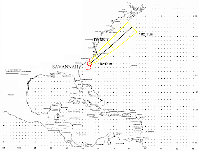
I do not see a huge outbreak Thursday, but in the NE ahead of the front there will be some morning sunshine and moisture in place, which will allow CAPEs to approach 1500 and LIs to range from -2 to -4. This will allow widespread convection to fire in the afternoon ahead of the cold front. Instability will be by no means great, but with a lot of shear in place I believe some storms will become severe. I know Matt and the SPC mentioned supercells due to the shear, but with instability pretty low I believe the threat for supercells is low. However, I believe that storms will try to organize into line segments, with slightly enhanced wind damage threats due to the stronger winds aloft. But again, with limited instability in place only a few storms will get strong enough to tap the stronger winds aloft and produce damaging winds. I cannot rule out a little bit of hail in the stronger storms but nothing huge hail wise is expected. In the morning if things look slightly more unstable I may need to add a 30% risk area, but at this time I give that a small chance of happening. Thursday I will have a in depth analysis of the two invests in the Atlantic, which may develop into tropical cyclones.

Wednesday, July 2, 2008

I Foregot What Day of the Week it is! This is for WEDNESDAY'S SEVERE

Wind shear, moisture, instability appear to be all favorable for a decent bought of severe wx on Wednesday into Wednesday night. MI is a bit of a question as moisture will be lagging there a bit, but it appears that by late in the day dews will be well into the 60s, which will allow CAPEs to increase to 1000-2000 over MI, and 2000-4000 over southern WI, IA, IL, and parts of MO, and LIs will also be -3 to -6 over MI, and -5 to -9 or lower over the rest of the higher risk areas for severe. This should allow widespread storms to develop and quickly become severe, and with decent shear in place damaging winds appear to be a large threat with many of the storms tomorrow. With the strong flow aloft I believe the storms will organize into squall lines with an enhanced damaging with threat. These areas of storms could organize into a MCS or two, which is indicated by the latest NAM and GFS. The SPC goes along with this adea as of the Day 2 outlook (I will probably be out cold by the new Day 1 outlook comes out). With the amount of instability, shear and slightly cooler air aloft, hail may also be a threat along few tornadoes. However, I do not foresee a large tornado outbreak.
NOTE: I am going to hold off on the moderate risk.
NOTE: I am going to again post all my forecasts that I usually post on the accu wx forums here, along with coverage of other major weather related events.