
 (Click on images to see full size)
(To avoid confusion, the Outer Banks are in the "low impacts" zone, and the shoreline of mainland NC is in the "minimal impacts" zone)
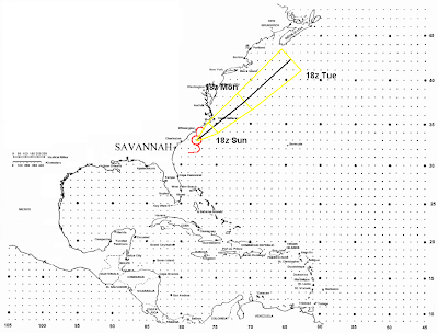
(18z=2PM EDT)
Well, the area of low pressure that was in the Gulf earlier in the week has played a trick on us. Instead of drifting through the SE US, and giving them some much needed rain, it tracked across Florida, and has since fed off the warm Gulf Stream, and has been named a tropical storm. Forecast Discussion:
Over the next day, Cristobal will continue to follow the very weak steering currents around the periphery of a high. So, a slow NE motion will continue. After that, an approaching trough will break down the high, so Cristobal will not be forced towards the coast. The trough will be bringing in a nice blast of westerlies, so an increase in foreword speed is expected. Ahead of the trough, steering currents will still be out of the SW, so as I said a NE motion is expected to continue. By Tuesday, the trough will catch up to Cristobal. This will cause a further increase in the continued NE motion, and will also cause Cristobal to become extra tropical. As for intensity, low shear and warm SSTs should allow for a little more strengthening over the next day or so. However, I do not expect a rapid increase in intensity, especially over the next 24 hours due to the center being exposed, and proximity to land. After that, the storm will move over cooler SSTs and shear will increase in association with the trough, so a weakening storm and an extra tropical transition will begin by late Monday. Intensity forecast:
18z Sunday: 50-55MPH
18z Monday: 60-65MPH
18z Tuesday: 45-50MPH
Other tropical notes: Bertha has again become a hurricane over the far northern Atlantic, but is soon to become extra tropical. It is by far the longest lived July storm on record (17 days and counting). The tropical wave in the Caribbean (Invest 94L) has not developed over the last few days, and is still just an open wave with no center of circulation. However, it is in a favorable environment for development, and may develop over the next few days as it moves over the Western Caribbean. This system is expected to effect the Yucatan Peninsula, and then the Western Gulf Coast, so all interests in those areas need to keep tabs on this system.
NOTE: This new layout which I am digging has one side affect. The warning box, blog archive and other weather links (recently added to tropical links) are all at the bottem of the page.
No comments:
Post a Comment