Wednesday, March 26, 2008

BREAKING NEWS: MAJOR SNOW POSSIBLE THURSDAY/FRIDAY


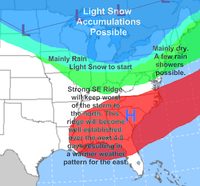
The storm that was supposed to put us in the warm air Friday looks to be doing the opposite. A front will stall near the Ohio river, putting northern Ohio in the cold sector. Cold enough for snow, it appears. Surface temps may be just a little to warm especially during the day Thursday but overnight Thursday night it will get cold enough for all snow, and perhaps a thin stripe of 4-7" between the lake shore and areas about 20 miles inland...most of it falling Thursday night. So, how will this system evolve? A wave of low pressure and precip will move towards Ohio tonight. Most of it will be rain, but north of I-80 especially there could be snow mixed in. Around 1" of accumulation is possible by tomorrow morning. Tomorrow wave one of low pressure/precip will move through. Most of it will be rain, but north of I-80 it could occasionally mix with snow especially early in the morning and late in the afternoon. No accumulations, as temps will range from 35-45 across northern Ohio to 55-60 near the Ohio river, with 45-55 in between, a large temp range, and too warm for snow to accumulate anywhere. Just a note a bit of a break in the precip is expected tomorrow afternoon. Thursday night is when things get interesting. Surface temps will cool to the lower 30s across northern Ohio, and even the mid to upper 30s in central Ohio, so northern Ohio will change to all snow and even down to near Dover/New Philly, and Findley it could mix with snow. Most accumulating snow will be Thursday Night, with 3-6" across far northern Ohio with a dusting as far south as areas like Canton. Friday morning things wind down but up to 1" of snow is possible Friday morning. Like usual, the track of the low is key. It tracks farther south and we have more snow, farther north much less snow. Stay tuned as this forecast may change over the next 24 hours.

Tuesday, March 25, 2008

Jimbo's Weather School: How to Read the Models: 500MB Height Anomalies

What are the 500MB height anomalies? They are how much higher or lower the 500MB heights are compared to normal. How is this important? Well, the lower the 500MB height is, that usually means there is more troughiness. If they are higher than normal that means there is ridging taking place. The jet stream usually resides between the troughiness and ridging. So you can tell if the pattern is favorable for a storm track. For example, on the map above, it shows a pretty favorable track for a strong Nor'easter. You can see a ridge of high pressure in the western US. That causes the jet stream to be more amplified, meaning it is running more vertical (or north to south), which can bring down more cold air behind (or north) the jet stream, and more warm air north in front of the jet stream, which can be more favorable for a storm to develop because extremes fuel storms. And a more amplified weather pattern often allows troughs with storms to really dig, allowing them to strengthen and not move quickly off the east coast. You can also see some ridging over the north Atlantic, or blocking. This will allow the storm from going straight out to sea (because it would block the storm). You don't want too much blocking, because the storm would just go around it and stay away from the northeast. You can also see ridging over the Arctic, which often forces cold air south from the arctic. You can also determine the three important teleconnections (AO, NAO, PNA) by looking at these maps...the amount of ridging over the Arctic determines the AO. Troughiness over the arctic creates a negative AO which often allows colder air to spill southward. Ridging over northern Canada creates a positive AO which keeps arctic air bottled up. So for a negative AO and cold air spilling down you want troughiness over northern Canada and the arctic and no ridging over Canada or the arctic. The amount of ridging over the Atlantic determines the NAO. Ridging over the Atlantic creates a negative NAO. The ridging over the western US determines the PNA. Ridging over the western US equals a positive PNA.

HYPE! East Coast Storm Around the 4th?


It has shown up almost constantly on the GFS and EURO the last couple of days, and the pattern would support it. A Nor'easter around April 4th. I don't like over-hyping storms so far out but the weather pattern would support it, as there will be a ridge over the west creating a much more amplified weather pattern which will allow the trough in the east to pull down cold air. There is also blocking over the Atlantic. Not enough to to suppress the storm to the south and out to sea and not enough to cause the storm to go west of the Appellations, so if a storm does indeed develop around this date it would have to go up the east coast. But, as is always the case about 10 days out things could change in the models and there are still things that need to be worked out like if it will be cold enough for snow south of New England. I will have more on this over the next week.

The Warm Side to the System Later This Week


There will be some severe weather with the storm system later this week. No huge outbreak. Not a ton of instability, there will be some extra lift/wind shear near the area of low pressure so that is where the best chance for severe storms will lie. I am in pretty good agreement with the SPC on this one. No huge outbreak just a slight risk event confined to near the low track. Flooding rain hopefully won't be an issue unless we get some training of thunderstorms.

Storm to Produce Snow, Ice Thursday-Saturday, But Where?


Another late season snow/ice event possible late this week into the weekend. As you can see on the second map though this will not be a huge east coast storm, just a storm riding up along a front and bringing warm air farther north. There is a threat for major snow/ice though on the northern end of the storm. While we won't get a huge storm and just a weak wave of low pressure, there will be some overrunning precipitation well ahead of the storm so many areas in the snow/ice zones could see 24-36 hours of snow/ice, and it could add up in some areas. Now the first map shows why this storm won't bomb out on the east coast of form a secondary low that moves up the coast. Just way too much blocking over the Atlantic. More updates later.

Monday, March 24, 2008

Clipper Produces a Stripe of Snow


A clipper will be passing through the northern Midwest and Great Lakes on Tuesday, bringing up a lot of warm air, and stirring up some gusty winds. There will also be a bit of a snowy side, but it will be well north of Ohio. Here in Ohio there could be a brief period of snow to start tomorrow late morning/early afternoon but after that it will change to rain.

Sunday, March 23, 2008

What Weather Will You Have to Deal With to Start the Workweek?

A pretty quiet weather pattern Monday/Tuesday...only a couple of things to note...east coast may and I stress may see some increased clouds/winds from the storm that will be passing well off shore Monday. Also the Midwest and Great Lakes will have another clipper to contend with with light to moderate rain/snow. Today the Great Lakes area is seeing light snow showers from a weak cold front. Up to 1" of accumulations in the Great Lakes today.

A Tuesday Clipper?

It looks like another fairly weak weather system will be affecting the region on Tuesday, this time with a mix of rain and snow. A clipper will ride through the northern Great Lakes, and will spread precipitation over much of Ohio, with the heaviest probably being over northern Ohio, as the SE ridge is going to be back and it will be impacting our weather all week long. It looks like southern Ohio won't see too much from this thing, maybe a line of showers (and thunder) with some gusty winds as a cold front gets dragged through late Tuesday into Tuesday night. Northern Ohio may see some steadier precipitation, and it may be cold enough that far northern Ohio sees several hours of snow to start the storm late Tuesday morning into Tuesday afternoon. It will not be a huge snow producer but as an early guess it seems reasonable to say 1-3" of snow could fall across much of northern Ohio before a change to rain late Tuesday. Northern Ohio will also see gusty winds as a blowtorch of warm air advection will reach into that area as well. Tuesday evening it appears northern Ohio will also see a line of showers and potent winds as the same cold front goes through there, just with slightly colder temperatures. This storm will not be a huge snow producer for anyone, but people in a lot of areas from the Great Lakes east through southern Ontario, Canada and eventually northern New England will see 2-4" of new snow. More updates as this clipper approaches...

As I noted on the map above our good old friend the Southeast ridge will be making a comeback this week and will cause a large pattern shift to spring east of the Mississippi for several days. We will see our largest taste of warm air for a lot of areas from the Plains on east especially the second half of the week. That means snow melt so for a lot of areas in the Great Lakes and New England where there is a lot of snow on the ground flooding is going to be a concern.

Saturday, March 22, 2008

Easter Forecast For Cleveland

No major travel problems but up to a half inch of snow accumulation is possible tomorrow with slightly higher amounts Sunday night and Monday in the Snow Belt.

Weather Disscusions

For Great Lakes and Midwest:
A pretty quiet weather pattern will take hold over the next couple of days. But, the weather will not be completely quiet as there will be a atmospheric irritation moving through the region tomorrow. A weak back door type of cold front will drift through the Great Lakes tomorrow and tomorrow night, sparking off some light snow showers. No more than a dusting of snow is expected with this disturbance, but it will temporarily bring down some more winter like temperatures. Highs will remain 5-15 degrees below normal Sunday for the whole region but will start to recover some on Monday especially if you head to or west of the Mississippi River. We will have a bigger weather system to contend with later Monday and on Tuesday, more on that later.

For the East:
The east will be just as quiet and cool as the Midwest/Great Lakes. There will be some light snow showers possible tomorrow into Monday over western New England from the same cool front that will bring light snow to the Great Lakes tomorrow. The east will also remain below average for this time of year tomorrow and Monday. Overall high pressure will dominate the weather and will keep any kind of storms away from the East through Monday at least.

Final Analysis for Monday's "Storm"

That map explains it all. Earlier in the week the chances of a major snow storm on Monday looked very promising. But as the week went on it slowly became more and more apparent that this storm would be suppressed to the south and stay out to sea. And now, two days before the storm, it is very obvious why the storm will stay out to sea. In my previous post I mentioned how strong high pressure will come down behind that trough of low pressure. Well the final product is shown above. The whole eastern half of the US will be under the protective umbrella of high pressure. Just no way a developing storm will be able to pierce this strong high pressure and move up the east coast. Some of the models have brought the storm slightly farther west this morning, but I think in the end the high pressure will win and the storm will stay out to sea.

Will the East get Snow This Weekend?


After up to 10" of snow across Ohio last night, will we dry out and stay snow less for a few days here? No. But will we see any major plow able snow? No. Will anyone in the east see anything heavy? No, nothing widespread. But as I mentioned there will be some snow showers. We will have a weak cold front/shortwave drift down into the Great Lakes/Northeast. It will be enough to spark off scattered snow showers, or maybe some rain showers south of the Great Lakes/New England. I do not see anything really accumulating with this weak system. After this shortwave passes, there will be some colder air over the Great Lakes and I could see some areas seeing 1-4" of Lake Effect off of any of the Great Lakes, but this won't be a major event. In my next post I will post my final analysis on the storm, or lack of one on Monday.

Friday, March 21, 2008

Clipper Tracking a Little Farther North

As I hinted last night, the clipper is tracking a little farther north, and that does change the forecast some. First, it brings the rain/snow line and area of lower totals farther north, so for Chicago instead of being on the edge of the 12"+ line like yesterday you are now on the edge of the 6" line. Areas just north of Chicago will likely see around a foot of snow. The threat for accumulating snow has shifted into Detroit. It appears they will be on the northern edge of this system but will see 1-3" in the city and 3-6" immediately south of the city itself. For Ohio, the mix line will be a little farther north, but not much farther north than it was. But, the higher totals have been shifted to the NE a bit, so it now appears that even Ashtabula county could see 2-4" of snow. Just a few small changes overall as the clipper is tracking a little farther north, but the bottom line is this thing will still bring a period of heavy snow for quite a few areas

Some Thoughts and Concerns About Clipper

I think the snow map I posted a few posts ago will be close to reality, both with the placement of the the highest totals and the rain snow line. But, there is major bust potential here, for a major city. Chicago which is on the southern edge of heavy snow on my map is where I'm talking about. Why? Warm air. This storm will pull in a lot of warm air. Southern IL, MI, and IN will be in the 60s tomorrow. Chicago which currently is barely in the heavy snow zone could easily see some warm air come in and change the precipitation to rain and significantly cut down on totals. Other then that everything looks on track...


Side note:
Sunday-Monday actually looked interesting to me on the Oz GFS...in terms of some accumulating snow. The model showed a series of shortwaves coming through, each with some lift and cold air. These could easily interact with Lake Erie and deposit a few inches of snow in the Snow Belt Sunday and Monday. Not sounding an alarm yet just pointing out that interesting happening showing up on the GFS.

Thursday, March 20, 2008

Snowstorm Monday? Update:

Don't need any maps to explain this. All the models are showing a suppressed storm for Monday/Tuesday, and showing very little snow for anyone in the Midwest or northeast. As I learned with the last "storm" don't go against the models when they are in such good agreement so far out. I will have more updates on the clipper and this coming "storm" later tonight.

One Heck of a Clipper!


A very strong Alberta Clipper will come through Friday-Saturday, and it will pack heavy snow from the upper midwest and into Ohio. Chicago may be near the bullseye with up to a foot of snow possible. Across Ohio still going for 3-6" in NW and north central Ohio, 1-3" or less in far NE Ohio, and less to the south due to rain mixing in. The clipper will also be weakening as it crosses the area so far eastern Ohio will see less precip and a smaller potential of heavy snow.

Wednesday, March 19, 2008

More Details on the Friday Clipper


Not a huge snow storm, but we will see some moderate snow Friday-Saturday from the upper Midwest towards the northeast. This WILL NOT be a huge storm but will give some areas some fresh snow to start off this spring.

Sneaky Snowstorm TODAY?!?


Sneaky? No, not if you remember the map above that I posted on Monday. Now, obviously no one in Illinois or Michigan is going to get any snow, but they did over the last couple days. (the map is two days old) But as I was thinking two days ago areas in northern Ohio could see a quick few inches of snow this evening. As seen on the radar above snow is already falling across portions of Ohio, and the is supported by official obs of snow within the last two hours at Lorain County Regional Airport and Hopkins's airport. Now just to clarify the map above is not for additional snowfall after today, because I made it Monday, so some of that 12"+ has fallen over New England, but I do expect most of the amounts shown over Ohio to be very close to reality. The precipitation is going to start falling on me very soon so I will post a comment that contains an observation of the precipitation type.

Tuesday, March 18, 2008

Snowstorm? Update:

The storm got lost in some models and pushed well south by others, and at this far out from the date of the possible storm all we could do was sit back and watch the models try to work things out. And it appears they are trying to do that. The EURO which is the most accurate mid-range model jumped to a solution showing an inland runner up the east coast, and the models that lost the storm are starting to bring it back. In the end I think the track will end up closest to the EURO's current track, and that could give inland areas of the NE, especially areas in the mountains some heavy snow. Here in Ohio it looks like we may be on the western fringes of some heavy snow so stay tuned!