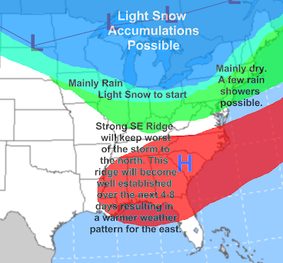
 It looks like another fairly weak weather system will be affecting the region on Tuesday, this time with a mix of rain and snow. A clipper will ride through the northern Great Lakes, and will spread precipitation over much of Ohio, with the heaviest probably being over northern Ohio, as the SE ridge is going to be back and it will be impacting our weather all week long. It looks like southern Ohio won't see too much from this thing, maybe a line of showers (and thunder) with some gusty winds as a cold front gets dragged through late Tuesday into Tuesday night. Northern Ohio may see some steadier precipitation, and it may be cold enough that far northern Ohio sees several hours of snow to start the storm late Tuesday morning into Tuesday afternoon. It will not be a huge snow producer but as an early guess it seems reasonable to say 1-3" of snow could fall across much of northern Ohio before a change to rain late Tuesday. Northern Ohio will also see gusty winds as a blowtorch of warm air advection will reach into that area as well. Tuesday evening it appears northern Ohio will also see a line of showers and potent winds as the same cold front goes through there, just with slightly colder temperatures. This storm will not be a huge snow producer for anyone, but people in a lot of areas from the Great Lakes east through southern Ontario, Canada and eventually northern New England will see 2-4" of new snow. More updates as this clipper approaches...
As I noted on the map above our good old friend the Southeast ridge will be making a comeback this week and will cause a large pattern shift to spring east of the Mississippi for several days. We will see our largest taste of warm air for a lot of areas from the Plains on east especially the second half of the week. That means snow melt so for a lot of areas in the Great Lakes and New England where there is a lot of snow on the ground flooding is going to be a concern.
No comments:
Post a Comment