Wednesday, April 30, 2008

Friday Severe Weather *Outbreak?!?

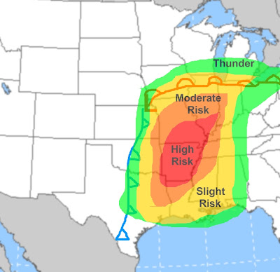
This is the severe threat for Friday and Friday night. Discussion below:
-From northern Missouri south into AR storms will be ongoing in the morning. These will weaken by afternoon but debris clouds will linger long the cold front perhaps limiting the severe threat some. However a strong jet stream will be blasting along and just ahead of a strong cold front, and CAPE values will be around 1000 J/kg which is supportive of some thunderstorm development. I think the main threat on Friday will be a squall line along the cold front. Instability will be marginal but with the extra lift of the front storms will likely fire along it. Again a strong jet stream will be blowing not to far aloft which will enhance the damaging wind threat. But I do not think too much of the tornado threat because there will be a lot of clouds, especially from whats left of the morning storms. This will limit how unstable things can get and limit how many super cells will be able to develop ahead of the line. I will post an updated map and discussion tomorrow.

Thursday Severe Weather

Before I get into the disscusion, here is what my risk areas mean:
-Thunder: A 20%+ chance of hearing thunder. Very little to no severe weather expected.
-Slight Risk: Thunderstorms will likely develop in the outlook area. Severe weather is possible but reports will likely be scattered. A large outbreak is not expected.
-Moderate Risk: Thunderstorms will develop in the outlook area. Organized severe weather is likely with widespread reports possible. Also a higher risk of exceptionaly severe weather.
-High Risk: A major severe weather outbreak is expected. Widespread severe reports likely with several reports of exceptional severe weather likely. (Exceptional severe weather is strait line winds of over 80MPH, hail greater than 2", and/or hail.)
-Now Thursday's disscusion: Most of Thursday moisture will be advecting northward. A strong cap is likely going to be in place. By late afternoon the moisture will be borderline enough for severe and will continue to increase throughout the evening. This along with winds backing at the surface (adding convergence along the dryline) will probably weaken the cap some. There are questions on if storms will be able to fire Thursday evening. I think the cap will weaken enough for isolated storms to develop Thursday evening. These storms could get quite intense with very high CAPEs and a lot of wind shear and jet stream energy. All severe modes are possible tomorrow between 21z and 03z as these storms start to develop. The wind shear and strong high instability could favor strong tornadoes if storms develop. Late tomorrow night (after 03z, or 10PM CDT) the jet stream will really speed up, with over 50 knots at 850MB expected over OK/AR/Missouri. Also, the cold front will catch up to the dry line late tomorrow evening. This will erase any cap problems that will keep the dry line from getting too out of control. So tomorrow night storms will likely develop along the cold front, and will likely organize into a squall line/MCC. (Mesoscale Convective Complex). The tornado threat will be smaller with this as these storms will initilize at night. However damaging winds could be a large threat, with a very strong low level jet and cold air flooding in behind the front. The cold front storms that will develop overnight is what the moderate risk is for, as this area will likely see a decent line of storms come through. Friday's map/disscusion will be posted in a little bit.

Monday, April 28, 2008

Tomorrow: Thankfully Quieter

Tomorrow, I am proud to announce that there is no risk for severe weather anywhere in the continental US. This comes off a day where three tornadoes terrorized southeast Virginia. So far, NO deaths related to the tornadoes (one was reported but it was unrelated to the tornadoes) however over 200 injuries have been reported. One tornado was rated an EF1, and the tornado that blew through Suffolk, Virginia and the Driver, VA area could have been an EF3 (it has not been officially classified yet) after the first look at videos and pictures I have seen. Tomorrow the east will fall well below normal. There could actually be some snow in parts of the Apps or New England tomorrow. The central US will be quiet. The next system will be coming into the NW with some colder air and precip with it. This could lead to the development of a system that may produce some more severe weather Thursday-Saturday. Details are still un-clear but I will have more details on this later.

Sneaky Tornado Outbreak: Parts of Southeast Virginia Devestated

A sneaky severe weather outbreak occurred today, and some extreme tornado damage has been reported. Here are two weather forum threads with links, pics, and discussions on these tornadoes:
Eastern WX
Accuweather

Sunday, April 27, 2008

**Corrected Key on Rain Map**

I corrected the key on my rain map...It originally said .5"> rain and so on, but it should have said .5"< rain and so on. Same map just a corrected key. Same thoughts on the whole system as earlier (see second post down from this one for complete discussion on the storm). Ohio forecast details:
Tonight: Periods of rain. Heaviest rain east. Low 40-45 northwest half, 45-50 elsewhere.
Monday: Periods of rain early, than mostly cloudy. Scattered showers and thunderstorms possible especially western Ohio. Small hail is possible. Chilly. High 47-53 northeast, 53-60 elsewhere.

The Storm Zone


A large area of general thunderstorms with some stronger ones developing in the southeast due to an old, stalled out frontal boundary. Not much severe because there is a lot of cloud cover in these areas, but a few storms may have marginally severe winds or hail this afternoon/evening. In the enhanced storm zone an organized line of storms has developed because more sun has broken out in this area. This could produce a few severe weather events by this evening but the dynamics aren't there to produce widespread severe weather.

More on Tomorrow's Storm


First the general set up. There is an arctic blast coming southeast, but there is a pretty mild, moist air mass in place. This will cause a storm to form along an old frontal boundary and move north-northeast. This system will bring a lot of moisture with it, because there is very moist air ahead of it and a huge temperature contrast. This will cause the storm to bring periods of steady, moderate to heavy rain. A lot of areas will see over .5" of rain, and in areas like here in Ohio, that is needed rain because things are getting a bit dry. Areas in the Carolinas could see 1.5-2.5" of rain because they will see two days (plus Saturday three days) of thunderstorms. This could cause minor flooding problems. Parts of the northeast could also see some heavier rain totals because of some moisture being picked up off the Atlantic enhancing rain totals. There could again be minor flooding problems in portions of the northeast/Mid Atlantic especially where it rained a lot yesterday, but the key word is "minor". This will not be a huge flood event. There will also be some snow behind the system. On Monday a shortwave will be diving south from Wisconsin through IL and Indiana, and this will cause some light snow accumulations in Wisconsin, maybe even some snow showers in northern IL. As this dives south it could cause instability thunderstorms Monday afternoon over IL and Indiana, and if these don't mix with snow there could be some pea sized hail because of very cold air aloft. Speaking of storms, there is a slight risk of severe storms in the east on Monday. The area under the slight risk is where there appears to be enough instability tomorrow afternoon for storms to develop. With such a huge amount of cold air coming in these storms will contain a damaging wind threat. There is not going to be a lot of wind shear so hopefully tornadoes won't be a problem. These storms will probably be low topped due to the lack of a lot of instability so hopefully hail shouldn't be a big problem, except for in the biggest storms.

Mild Temps, Sunny Skies, For Now...


After a cold front caused lots of rain and storms in the east yesterday, a small hole of sunny skies has opened up. Under that hole temps today will be near normal, or in the 60s with low humidity, definitely a good day to get outside and enjoy! But on all sides of this quiet area there is unsettled weather. Along the east coast and in eastern New England the same old cold front has really lost momentum, and still is producing low clouds and showers. These will slowly move east today but could hamper outdoor plans in the areas I mentioned above. To the west cold air is poring south and that is causing a storm to develop along that frontal boundary over the southeast. This will eject north-northeast bringing a cold rain with it. Today the storm will not be partulary organized, but it will be the focal point of showers and storms from Texas to the Carolinas. There could be isolated severe weather and heavy rain with the storms but there will be a lot of clouds limiting instability and nothing else to support severe weather, so I agree with the 5% probs of hail and wind from the SPC. I will have the details what this storm will do over the next couple days as well as the cold air it will bring down soon. As I used to do I will start giving the detailed Ohio weather forecast now at least once a day:

Forecast Details: Today: Sun early, increasing clouds from south to north. Rain possible by evening especially southwest. High 63-67 north (lakebreeze?) and 66-72 south.

Tonight: Periods of rain. The steadiest rain will fall over eastern Ohio. Low 41-46 north and west and 45-50 elsewhere.

Saturday, April 26, 2008

The Storm Zone


I am starting a new way to tell you what the general area I will be watching for a particular extreme weather situation, usually strong to severe storms. This will be called "The Storm Zone" and whenever there is an area of extreme weather I will be watching I will post a map like the one above with an area outlined and a discussion on what I think will happen. The Storm Zone is comparable to the SPC mesodiscustions although they may be much larger during a large outbreak so there is just one covering the whole outbreak. In tonight's storm zone a front with arctic air behind it will collide with much warmer and more humid air. This will cause a low to develop later tonight. But until then a dry line is also slicing into The Storm Zone and that is already causing super cell thunderstorms to develop. These storms are easily able to maintain severe status because because of ML CAPEs of over 1500, Lifted Indices of -4 to -6, and steep low and mid level lapse rates. These storms are rotating because the winds are coming from all different directions at different levels. Surface winds are backed to out of the east, 850MB winds are out of the southeast, 700MB winds are out of the southwest, and the winds 500MB and above are blasting out of the west. Not good. These steep lapse rates and lifted indices and high CAPES will cause strong up drafts and possibly pretty big hail in the strongest storms. The low dew points could result in strong downburst winds. Now, into the overnight tonight a late season arctic like front will come plunging into northern Texas. This will draw moisture towards it and likely be the focus of storms later tonight. Wind damage will be a threat along the cold front because there is a huge amount of cold air coming in and the jet stream will really be getting energetic late tonight. More on this arctic outbreak, which could bring Ohio some snow tomorrow.

Busy Weather: More Severe Weather


Today we will have one cold system exiting to the east and one developing in Texas. The cold front in the east and southeast will cause storms to fire up. These storms could be strong in the southeast, and some severe storms are likely farther north where there will be slightly better dynamics. In Texas?Oklahoma a low will just be starting to develop. It will pull enormous amounts of cold air southward behind it, and will likely cause an area of storms to develop tonight. This storm system will continue to move NE over the next three days bringing some severe weather and flooding rains with it. It will also draw down unseasonable cold air which could cause late season snow showers in the Great Lakes, New England, and in the Appellations Monday-Wednesday. More on this later.

Friday, April 25, 2008

SPC

Sorry but again I don;t have much time this morning, but here is the SPC disscusion for today's severe weather. Does look like a semi decent outbreak if storms can break the cap this afternoon from what I have looked at this morning.
SPC AC 250553 DAY 1 CONVECTIVE OUTLOOK NWS STORM PREDICTION CENTER NORMAN OK 1253 AM CDT FRI APR 25 2008 VALID 251200Z - 261200Z ...THERE IS A SLGT RISK OF SVR TSTMS FROM THE UPR MIDWEST/CNTRL GRTLKS SWWD INTO E/SCNTRL TX... ...CNTRL GRTLKS TO E/SC TX... A MID-LVL TROUGH EMERGING ONTO THE PLAINS WILL SLOW AND TAKE ON A NEGATIVE TILT OVER THE UPR MS VLY REGION TONIGHT AS A SECONDARY IMPULSE DIGS SEWD ACROSS THE NRN ROCKIES. THE ASSOCD SFC LOW WILL DEVELOP NEWD FROM NEB AT 12Z TO N WI BY THIS EVE WITH AN INTENSIFYING COLD FRONT SWEEPING SEWD INTO THE MS VLY...OZARKS AND CNTRL TX BY TONIGHT. THE FRONT WILL BE A FOCUS FOR PSBL SVR TSTMS TODAY AND TONIGHT. EARLY THIS MORNING...AN INTENSIFYING MCV WAS NOTED OVER CNTRL NEB. THIS FEATURE SHOULD PROGRESS ENEWD TODAY ALONG THE FOOTPRINT OF THURSDAY EVENING TSTM CLUSTERS OVER WI...CNTRL/NRN IA AND ERN NEB. COMBINATION OF ENHANCED LOW-LVL FLOW ALONG ERN PERIPHERY OF THE MCV AND ADDED LARGE SCALE RESPONSE TO THE APCHG TROUGH SHOULD SUPPORT A WIDESPREAD REGION OF TSTMS FROM THE MID-MO VLY NEWD INTO WI DURING THE MORNING AND PSBLY INTO THE EARLY AFTN. AS A RESULT...THE EFFECTIVE BAROCLINIC ZONE MAY REMAIN IN ITS CURRENT AFOREMENTIONED ORIENTATION THROUGH MOST OF THE DAY...LIMITING DESTABILIZATION NWD INTO THE UPR MS VLY/CNTRL GRTLKS REGION. THIS OTLK WILL MAINTAIN CONDITIONAL SVR PROBABILITIES OVER MOST OF WI EWD INTO PARTS OF MI. LATER SHIFTS CAN BETTER ASCERTAIN HOW MORNING CONVECTION MODULATES INSTABILITY FIELDS. WHATEVER THE CASE...THE MORNING ACTIVITY WILL PROBABLY OFFER AT LEAST ISOLD HAIL/DMGG WIND GUSTS. FARTHER SW...LARGER SCALE HEIGHT FALLS ASSOCD WITH THE PRIMARY TROUGH WILL BEGIN TO OVERSPREAD THE WARM SECTOR CHARACTERIZED BY 60-65F SFC DEW POINTS FROM ERN IA SWWD INTO WRN MO AND ERN OK DURING THE EARLY AFTN. LOW-LVL HEATING JUST AHEAD OF THE FRONT AND MODEST COOLING ALOFT WILL WEAKEN INHIBITION AND RESULT IN DEVELOPMENT AND/OR STRENGTHENING OF TSTMS. A MIXED-MODE OF LINEAR AND PSEUDO-DISCRETE CELLS IS LIKELY TO EVOLVE WITH LARGE HAIL AND DMGG WIND GUSTS THE PRIMARY THREATS. A SLIGHTLY MORE CONCENTRATED AREA OF SVR POTENTIAL MAY EVOLVE SOMEWHERE OVER NERN MO/WRN IL NWD TO THE SRN PERIPHERY OF MORNING ACTIVITY WHERE STRONGER LARGE SCALE ASCENT TRANSLATES ACROSS THE REGION. ALL STORMS WILL PROBABLY PEAK BY MID-EVE OVER THE MIDWEST AND MID-MS VLY REGIONS BEFORE THEY MOVE AWAY FROM THE NARROW MOIST/INSTABILITY AXES AND AS THE LLJ TRANSLATES NWD INTO THE GRTLKS REGION. FINALLY...STRONG HEATING WILL EXIST ACROSS CNTRL/E TX DURING THE DAY WITH CURRENT MID-60S SFC DEW POINTS BEING MAINTAINED. VERY STEEP MID-TROP LAPSE RATES ATOP THIS MOISTURE WILL CAP OFF SFC BASED PARCELS UNTIL LATE IN THE AFTN/EARLY EVE. AT THAT POINT...SRN PERIPHERY OF THE PLAINS TROUGH WILL GLANCE THE REGION AND LIKELY SUPPORT TSTM INITIATION ACROSS NERN/NCNTRL TX. THIS ACTIVITY WILL THEN BACKBUILD SWWD INTO PARTS OF SC TX DURING THE EVE HOURS. STRONGER DEEP LAYER SHEAR WILL EXIST ACROSS NE TX...BUT GIVEN THE STRONG INSTABILITY EXPECTED AND SUSTAINED FRONTAL CONVERGENCE...STG-SVR TSTMS WILL BE POSSIBLE...INCLUDING BRIEF SUPERCELL STRUCTURES WITH LARGE HAIL. SOME OF THIS ACTIVITY MAY PERSIST OVERNIGHT AS IT MOVES INTO THE SABINE RVR VLY/UPR TX COAST WITH SW SIDES OF ANY GROWING TSTM CLUSTERS REMAINING STG TO PERHAPS SVR WITH DMGG WIND GUSTS/HAIL.

Thursday, April 24, 2008

Friday Severe

No time to write out a disscusion. I think the bigger threat will be up in IL/WI. I will try to write a disscusion as fast as I can tomorrow a little after three when I get my first chance
.

Late Post: Quiet Now, But Some Severe Will Develop

I finally got around to looking at weather at around 8 and saw the moderate risk and thought that the severe weather was already ongoing. It is really just beginning. There are some outflow boundary thunderstorms over Minnesota and Iowa and even eastern Nebraska. These are generally strong but not really severe because there are no dynamics really behind these storms. With the heat and humidity the outflow boundary was enough to fire them up. These should slowly weaken as the evening goes on. The area of bigger concern is the storms that are just starting to initiate in central Kansas into Nebraska. This is where three vorticies are working together to bring the dynamics like heat and moisture from the south, cold from the north, and low level jet stream energy which is also causing wind shear. These elements are allowing the storms that are developing to quickly become severe. There is a huge hail threat as there is chilly air just aloft of these storms. This could also cause very strong downburst winds with these thunderstorms. There is some wind shear so there is a brief tornado threat but it seems that storms are becoming outflow dominate fairly quickly after developing, and this is not favorable for long lasting tornadoes. Late tonight as these storms continue to move NE and the jet stream speeds up these storms will likely organize into a derecho. Tomorrow also has a severe threat. I hope to post on that by 10PM.

Wednesday, April 23, 2008

Severe Weather Today


Severe weather is already starting to break out across the southern Planes this afternoon due to a low pressure moving NNE along a frontal boundary. This low is pulling heat and humidity northward and packing some jet stream energy which will allow storms to develop and become severe. Here is what is expected to happen today/tonight:
-Clusters of thunderstorms will continue to develop across Texas and Oklahoma this afternoon. These will likely produce severe hail and high winds. There could be some embedded super cells due to the jet stream energy and strong surface based cape which will will create a tornado threat especially in Texas/Oklahoma this evening as this is where an area of stronger jet stream energy will be and where instability will be the highest. These areas of storms could form into more of a derecho type event overnight tonight.
-Other storms will occur farther north in the warm sector as it will be very unstable and there will also be a strengthening jet stream. The storms farther north may be a little less widespread but still could be pretty strong.
-Severe weather will continue tomorrow and Friday. More on this later.

Sunday, April 20, 2008

This Weeks Weather Discussion

Click on image for ledgable maps...
Two systems will affect a lot of the country this week. They will both be waves of low pressure along a cold front. The first one will develop over the Texas Panhandle Monday afternoon. It will race NNE along the cold front. On Monday there will be a slight risk for severe storms along the front. We could see some hail/high winds and MAYBE a couple of tornadoes. On Tuesday the low will be racing into Canada. Again some showers and storms along the front but any severe will be limited. On Wednesday the front will continue to loose momentum as it heads into a high pressure. It could produce a few showers and thunderstorms along and ahead of the front but nothing too widespread or severe. There will also be very warm air ahead of the cold front. The next system will develop early Friday over NW Texas. It will track along the same frontal system, which will be a little farther south than earlier in the week. The details are not yet clear on this system but this system will pull up very warm air and will have on thing the Monday-Tuesday system will not: Jet Stream energy. So a severe weather outbreak is not out of the question Friday into Saturday. This system will drag the cold front southeast all the way to the east coast and into the southeast. An chilly air mass will come in behind it, and it would not be all that surprising if we see some rain/snow showers over the Great Lakes and maybe into the northern Apps. Some frosts/freezes are also possible in the Northeast. More on the possible severe weather and chill that will follow this week...

Today's Weather Disscusion


Very quiet today except for in the Mid-Atlantic and Southeast, where a cut off low is producing a lot of rain and some severe weather in North Carolina and Virginia. There is plenty of heat and humidity and CAPE, and there is actually a moderate amount of wind shear. This is allowing a lot of strong storms to develop and produce large hail and strong winds. The shear is also allowing a few storms to rotate and prompt tornado warnings this afternoon. Due to the lack of heat and humidity north of Virginia the severe threat will not creep north into the Mid-Atlantic. But, a steady flow off the Atlantic Ocean is pumping moisture into the Mid Atlantic, and those areas are seeing a lot of rain. Some flooding problems are expected. Outside of those areas, things remain very quiet across the US. A system will work across the US this week with rain and storms but not much severe weather. More on this system this evening.

Saturday, April 19, 2008

Still Pretty Quiet Weatherwise, But Fault Lines Become a Little More Interesting

A cut off low produced rain, thunderstorms, cold air funnels, and even the real deal warm air funnels (tornadoes) across a lot of areas today. There were two tornadoes this evening across N.Carolina with some moderate damage. There was a swath of thunderstorms also that affected areas in the Carolinas and the Virginias with some hail/high wind reports. Showers extended back through Ohio, Indiana, and Illinois, and in Indiana/Illinois there were several reports of cold core funnel clouds or "cold funnels." These usually don't touch down and form from rapidly rising cumulus clouds, some of which don't even produce rain. If they do touch down there is little to no damage. This mess caused by this cut off low is west of some warm weather. 70s and 80s stretched well into New England today with several record highs broken. Tomorrow it will be slightly cooler in the northeast but still very warm. The cut off low will drift East Sunday and produce more showers/storms over the Apps and eastern Ohio Valley as it drifts ESE. In the west a system produced some wintry conditions with over a foot of snow across parts of Montana and instability snow showers to VERY low elevations in the Seattle area. There was snow mixed in near sea level in some areas especially Friday. The system causing a snowstorm in the west will spawn a storm system over NW Texas late Monday. This will track NE bringing thunderstorms with it. I do not think we will see a huge severe weather outbreak due to the lack of dynamics and a strong jet stream but, considering the contrast of air masses associated with the system some severe weather and heavy rains are expected from the Planes east. And yes I did not miss all the news about the 5.2 earthquake in SE Illinois Friday morning and the aftershocks afterward. This earthquake occurred in the Wabash Valley fault system, adjacent to the New Madrid Seismic Zone. ***Before you read the rest of this post let it be known I am not an earthquake expert and all the info I provide on here is just compiled based on what I have heard/read from people who do have some knowledge in the field of geology.*** It was felt as far away as Michigan, Ohio, Georgia, and Arkansas due to the type of sediment that makes up the crust in the region (it helps the seismic waves travel farther). Luckily the New Madrid fault did not rupture like it did in 1811-1812, when a series or earthquakes, a few topping 7.0 on the Richter scale devastated a large area, with the center of the destruction being New Madrid, Missouri. Earthquakes in the 4.0-5.0 range are slightly rare but not all that uncommon along the New Madrid fault, although Friday's 5.2 was the biggest in about 40 years. If the New Madrid fault goes and produces a 7.0+ quake the type of sediment that makes up the crust in the region would lead to a large area of destruction. The odds of this happening in the next 50 years are low, less than 10%. Studies have found that the New Madrid fault ruptures and produces large earthquakes every 400-500 years, and the last time it ruptured was about 200 years ago. So hopefully this earthquake is just a harmless little shake (which it likely is, considering minor earthquakes aren't rare along the New Madrid fault) and not a foreshock to a much larger earthquake (it likely isn't a foreshock). More on this issue if any more notable earthquakes occur near or on the New Madrid or any Midwestern faults. Also will have an update if there is anything notable in California (which will most likely happen within the next few decades, luckily most people out there are aware of this constant threat).

Wednesday, April 16, 2008

Weather Disscusion


Relatively quiet weather to continue over next five or so days. As you can see on the surface map high pressure and quiet weather continue to dominate the east. As you can see on the temps map the whole east is very warm and will get slightly warmer over the next couple of days, but as the cut off low moves east it will bring some slightly cooler air. Here is the cut off low forecast/discussion:
-On the surface map, you can see a low over New Mexico. This low will cut off from the main flow because a split flow jet stream will be dominating. The storm will be between the two jet streams and the steering currents so it will just drift around Thursday-Sunday. As the storm drifts around it will bring some moisture and cooler air with it, so 1-2 days of clouds, showers, and slightly cooler weather can be expected with this system, especially north and west of it. There could be some snow in the Rockies tonight/tomorrow, and some severe weather in Texas/OK/AK Thursday-Friday. Other than that this system will bring little more than clouds and showers.
-After the upper low around 3 days of quiet weather will befall areas in the east. Temperatures will shoot up with a southerly wind. A front will set up from the Rockies through the northern Plains along the jet stream ahead of an approaching trough (see fourth image). Waves of low pressure will ride up this front as it slowly moves east. Since the front will be moving slowly some areas could see a couple days with a chance for rain and storms since heat and humidity will be surging northward well ahead of the front. This could cause some flooding problems. There could also be some severe weather along and ahead of the cold front. Right now it does not look like a huge outbreak but it will need to be monitored. After this front moves through, (by Monday in the northern Plains, Ohio on on Wednesday, and the east coast late Thursday if nothing changes from now) there are some questions but below normal temps are possible in a lot of areas. More on this system later.

Monday, April 14, 2008

Tomorrow's Quiet Forecast Map

High pressure will dominate anyone east of the Rockies tomorrow, and for days to follow. The east will still be cool but temps will start slowly moderating. In the Plains a southerly flow behind the high and ahead of the system affecting the NW will pull warm air northward. The system affecting the Northwest US will bring some scattered mainly light precipitation and cool air, so snow levels will lower to around 1000' late tonight into tomorrow morning. This could result in a few more inches of snow in the ski resorts through tomorrow. Warm air advection will take over tomorrow and snow levels will rise. A low will develop off the Southeast coast. Some showers could brush the Carolina coast lines, but in general this low will move out to sea. Expect a warming trend this week as I have been saying and a good dose of sun in the east! Get out and enjoy!

Quiet Weather Today

As I said yesterday high pressure will be settling in over the east over the next day or so, and quiet weather will prevail across much of the country. Today there are a couple of irritations, but they are small. There is a upper low over the SE US which is causing instability showers to develop, and yes, in the higher elevations some of the showers could have a little snow mixing in even through tonight. Tomorrow that low will continue to weaken/move off to the east. It will be a cold night across a lot of areas and a lot of frost/freeze advisories are up even into the south. Check your local NWS office to see if you are under on of those advisories. A weak system is bringing some precip to the NW but it is not a big deal. Over the next few days the high will completely cover the eastern half of the country. The western edge of the high will slowly be eaten away by several weak systems moving into the NW. It appears that by late this week into this weekend a cut off low could make it under the high pressure, producing some damp conditions from the Rockies points east. This does not appear to be a huge weather maker but I will have more on it this week. Under the high and ahead of the cut off low temps will be soaring to in some areas the warmest they have been this year, with sunny skies to boot! So enjoy the nice spring weather as it looks like winter is finally over! For good!

Sunday, April 13, 2008

Extended Range: WARM AND DRY!

Yes, it did snow a bit across northern Ohio today, and several times during the Indians game you could see the flurries flying. But, it didn't up to much if anything, maybe a dusting in Medina county and southern Cuyahoga because that is where the most steady precip fell today according to radar. But, the future looks much, much brighter weather wise. High pressure and a split flow jet stream will dominate the eastern 2/3 of the country for the next 10-14 days. This will result in above normal temps for a large area and preclude a lot of rain and severe weather for the next 10-14 days. So, it looks like April will continue to be above normal for much of the continent. Here is the whole 12z GFS ensemble 500MB height anomaly animation: As you can see that ridge will dominate the east for most of the run. Here is the 12z GFS 850MB temp anomaly animation: As you can see until around the 25th of April that ridge will generate above normal temperatures. You can see all of the GFS ensemble maps by following the link in my forecast center. This looks like a quiet few days weather wise. I will try to post once a day although I am sure I will run out of stuff to talk about...until Thursday or Friday when we will have a bit of a disturbance working across the country (maybe a little severe weather but this doesn't look like a huge outbreak)

Saturday, April 12, 2008

Did you Notice the new OHweather Blog Forecast Center?

I have compiled a list of all the high quality FREE webpages that have accurate, easy to read, and informative weather information. I look at most of these pages on a daily basis to make my forecast, and now you can! Not only can you use these links as you please, but you can add to it! I know I put a lot of links there, but there are a lot more free websites that I do not know about. So, if you find or currently know of a free weather website that you use a lot and is not on that list, feel free to leave a comment at ANY time, at the bottem of ANY post (if this one is off the page). Enjoy using this list for all of your weather information needs! I will add a tropics section when that time comes.

Weather Disscusion

We will be entering a very quiet weather pattern for the next several days over the eastern 2/3rds of the country. But first we have a little snow to get through:

Tonight-Sunday:
-A upper level low will be affecting the lower Great Lakes and Appellations. It will produce some instability showers, especially during Sunday afternoon. Maybe even some thunder over the Appellations. Some of the showers will fall in the form of snow, especially high up in the Appellations and areas in northern OH/PA. Some light accumulations are possible but there will be no problems on the roadways. Some light snow showers are possible even in northern New England especially tonight.
-Any way you cut it the eastern half of the country will be 10-20 degrees below normal Sunday and maybe even Monday. Areas that clear out could see frosts and freezes even into the south. There are freeze watches up for Sunday night in central Alabama.
-High pressure and above normal temperatures will dominate the west.

Monday-Wednesday:
-On Monday the east will remain well below normal in the east. Instability rain and snow showers will continue to fall in the Appellations. Snow could even fall in north Georgia/western South Carolina.
-A weak system will affect the Northwest. Some mountain snows and light rain elsewhere but it will be a very quick, weak hitting area of low pressure.
-The middle of the country and the Rocky Mountains will be high and dry and will start warming in the middle of the country and stay warm in the Rockies on Monday.
-The east will be completely dominated by high pressure on Tuesday and Wednesday. It will remain cool from the Apps points east but temps will slowly begin moderating under mostly sunny skies. One possible blemish will be a low pressure forming off the SE coast and will move NE. It could throw some precip back at the Carolinas on Tuesday.
-The west will cool off as a trough swings through. The chill will be short lived and only last 1-2 days.
-The Plane states will be near normal Tuesday and Wednesday and will remain dry.

Thursday-???(hype):
-As the western trough moves east and picks up a little bit of Gulf moisture it will cause the formation of a low pressure over the Texas Panhandle late Wednesday. This weak system will move NE spreading some rain/thunder from the southern Planes to the Appellations. It will fizzle some when it hits the Apps. This system will bring little to no severe weather.
-Through the next 10-14 days the pattern will remain more zonal than anything else which will preclude extended periods of ab-normal temperatures and keep the chances of a major spring storm low.

Friday, April 11, 2008

OHIO TORNADO OUTBREAK

A MAJOR SEVERE WEATHER OUTBREAK IS OCCURING ACROSS THE CLEVELAND AREA THIS EVENING. PLEASE WATCH LOCAL NEWS STATIONS FOR SEVERE COVERAGE. MY RECOMANDATION IS TO WATCH CHANNEL 5 FOR THE BEST COVERAGE (NO OFFENSE TO THE OTHER STATIONS CHANNEL 5 HAS THE BEST TECHNOLOGY)

Thursday, April 10, 2008

Friday Severe

Tomorrow will be similar to today. Not much more than a slight risk. Here is what I expect to happen:
-Pre-frontal trough will move through northern Ohio/PA tomorrow. In the afternoon this could strengthen into some embedded hail storms and maybe even a few damaging wind gusts over northern PA/SW New York.
-In the dry slot again clouds look like they will dominate. This will really limit the severe threat. There are two areas I have heightened concern for and I will get to that in a minute. But, in the dry slot I expect only isolated storms, a few of which could go severe. But they will be limited in numbers, because it looks like as today clouds will limit instability and keep a lot of storms from developing. But, there are small chances of either some storms breaking the cap despite the clouds or the clouds clearing. Both of these possibilities are small but if they happen we could have some tornado reports.
-Michigan hatched area: I think that area will clear out in the morning and early afternoon, and as the warm front lifts into that area it will bring added wind shear and it could be warm enough for severe severe storms to fire along the warms front. It appears at least a couple of tornadoes will form in this area.
-Ohio/PA hatched area: This is where the best jet stream energy will be IMO. I think this could help some isolated storms develop despite the clouds, and these storms could easily go severe. I do not necessarily think this area will clear out like Michigan might, but if in the outside chance it does look for several tornadoes in this area.

Another update tomorrow afternoon especially if conditions warrant.

Why is Today's "Outbreak" Underachieving?


And I am not just talking about my forecast, I am talking about the SPC, TWC, Accuweather and basically most of the major weather sources that put out forecasts. Quite simple: Clouds. Lets compare my outlook made on Tuesday to what actually happened:
-One area sticks out like a soar thumb...the high risk. Up until late today it looked like if there were a lot of tornadoes it would be in this area. It looked like there would be sufficient heating and upper support. We got a little of both but at different times. We got the upper support this morning and this afternoon, but it was cloudy and a cap was in place so storms didn't really get going. Late this afternoon a line of storms broke out but, the upper level winds were dying down. If the sun had broken out as it looked like it would super cells would have popped like crazy this afternoon but, the sun didn't really come out.
-The northern areas (slight/moderate risks) were more active. Even though it was cloudy there was so much jet stream energy to work with that the storms that did pop really got going, and even in Iowa along a warm front there was some activity. Now, considering this was made 48 hours before the actual event a 50-100 mile change in the warm front is possible and did occur. There have also been strong storms just SE of the low most of this afternoon/evening.
-So, how do I rate the individual performances? (at least the big one and myself)
SPC: C They did not go crazy and issue any high risks or anything like that, which I did, but the moderate risk area busted terribly. They did judge the warm front activity quite good IMO.
Myself: D- High risk area busted terribly. The northern areas of my risk area were better but still not that good, but I made the map two days before the actual event. I think the problem everyone had was clouds, which kept instability down and kept storms from developing. Tomorrow is a whole other day and we will see what we can muster tomorrow (map by 11PM)

Tonight's Severe Just Getting Underway

There are some severe storms fire now with tornadoes associated with them. Here is what I expect to happen the rest of tonight:
-A trough of low pressure with elevated convection with a low tornado threat will continue to move east through IL/IN tonight. The southern portion of this area however (central IL south) it is much warmer and more humid so there are tornadoes firing in along that trough of low pressure. These will also shift NNE tonight and eventually fissile into more of a hail/wind threat by late tonight.
-The actual cold front is located over NW Missouri/central Iowa and super cells are developing along that. These will slowly progress east tonight but only get to central IL by morning. The threat will lower tonight as day time heating is lost.
-In the dry slot over Missouri where the cap is being broken some super cells are breaking out. A few more will do that by 10PM CDT while daytime heating is still a factor, but later tonight the dry slot should dry out and any isolated super cells will weaken.
-So by morning the only severe threat will be along the trough of low pressure over TN/AL, and it will be low. In the dry slot where storms will be based more on surface heating and along the actual cold front things should be relatively quiet with just isolated storms by morning. But all those areas will fire back up in the afternoon Friday.
-Note: If the dry slot can become more pronounced tomorrow and more sun breaks out Ohio could see some super cells, but the key word is IF. More on Friday's threat later.

Wednesday, April 9, 2008

Quick Update

Don't have much time but will sneak in an update...
-Tonight's severe seems to be going as planned. So far one long tracked super cell that has produced major damage and storms really starting to get going over Texas.
-For tomorrow I will keep the same outlook map as yesterday. Minor changes may be needed but I really don't have time. This will be a large tornado outbreak either way you look at it, possibly over 50 tornadoes?!?
-Friday there could be severe weather farther east and even eastern Ohio could have a tornado threat.
-Sunday-Monday it will be cold enough for snow in northern Ohio, and ample moisture will be in place. Sunday will feature scattered rain/snow showers with no accums, Sunday night will be colder and there could be a little lake enhancement so light accumulations are possible. Temps will rebound by the middle of next week. I will try to have a much more detailed update tomorrow.

Tuesday, April 8, 2008

Thursday Tornado Outbreak


Here is my early map for Thursday/Thursday night's severe weather outbreak. Here is what will happen:
-The same low pressure that will give TX/OK severe weather tomorrow will eject NE. By late Thursday afternoon it will be over NW Missouri. This low pressure will have a vigorous low level jet with it which will cause very high amounts of wind shear, especially from Louisiana northward to as far north as Chicago. So if storms get going very strong winds and tornadoes are immediately threats. So the question is, where will the storms fire?
-I think the most intense storms, with the best threat for rotating super-cells will be from southern IL/NW Missouri south through Arkansas and even into northern Louisiana. These areas will have similar amounts of low level jet stream energy to work with, and much more heat and humidity, so storms will fire in those areas first and will be surface based, which favors tornadoes.
-Farther north there will be just as much wind shear/low level jet stream energy. So why only slight/moderate risks? Clouds/less heat/less moisture. That will slightly inhibit strong, individual, tornado producing super cells from developing as fast and as frequently. But, it should be known that in the slight/moderate risks area to the north of the high risk area any individual storms that do develop could rotate and easily produce tornadoes, I just don't think TOO many will do that.
-Along the cold front there will likely be a strong squall line. This will affect the slight/moderate risk areas, and even the high risk area. However, with the squall line the threat will be mainly high winds, and not many tornadoes. I think the squall line will develop farther north due to the forcing/added lift the front itself provides. I just don't think too many super cells will develop ahead of the squall line in the northern portions of the severe threat area.
-Along the warm front there may be some convection with a bit of a hail threat.
-Summary: Super cell thunderstorms will develop ahead of a cold front starting Thursday afternoon. They will be more potent and more widespread S.Illinois/central Missouri points south due to more warmth and humidity. Any individual storms that develop farther north could still spawn tornadoes. Along the cold front a squall line will develop and produce a damaging wind threat as far north as N.Missouri/N.Illinois. Along the warm front some storms that produce hail are also possible.
-I will have Friday's severe weather map later this evening.

Severe Weather...Not too Much Today, but Tomorrow the big Outbreak Begins

Tomorrow will be severe weather day 1 of this major three day outbreak which will affect areas from the southern Plains all the way into the Appellations. Here is what will happen tomorrow:
-A cold front will stall out over northern TX/AR. This could light up a little in the afternoon.
-But in the late afternoon a low pressure will start approaching from the Rockies. This will cause the cold front to move back north as a warm front.
-A dry line/cold front will trail the low pressure. There could be isolated severe thunderstorms (an isolated tornado?) ahead of the dry line, but the main storm focus for tomorrow/tomorrow night will be along the dry line. This dry line will light up tomorrow evening. We could see some rotating storms along it in the mid evening hours (7-11PM) but as the storms really get going tomorrow night a strong squall line will likely develop on the squall line and race ENE. The squall line will be strongest in the moderate risk area.
-Along the warm front there will likely be some storms that develop tomorrow evening (similar to last night?) and continue to move NE tomorrow night. These storms will likely produce hail as the main threat, but there could be some rotation but there may not be enough surface based CAPE on the warm front to produce tornadoes.
-Summary: A dry line will light up with a squall line and maybe isolated tornadoes across TX tomorrow evening. There could be some hail producing storms on the warm front. Some tornado producing super cells may develop ahead of the dry line across Texas, but this won't be a huge outbreak but I could see 8-16 tornadoes being reported. If we get warmer and moisture faster across TX tomorrow more super cells could get going ahead of the dry line sooner and that would mean more tornadoes before we loose day time heating tomorrow night which will signal the transition to a squall line/wind/hail event.
-We will see a bigger outbreak (a huge one, actually) Thursday-Friday, and on Friday even Ohio could see some severe weather. More on this later this evening.
-Today's severe weather is slow to get going. Not a huge outbreak but there will be some severe weather this evening. I agree with this afternoon's SPC's severe weather map.

Monday, April 7, 2008

Tuesday's Severe...Comments on Tonight's Severe...Stressing the Major Threat Thursday

Tomorrow there will be a moderate sized sized severe weather outbreak. We will have plenty of heat and humidity ahead of a cold front and some wind shear especially near the low pressure in the warm sector and along the warm front. These areas could see a few tornadoes, and actually anyone in the red zone has a chance of some isolated tornadoes. This won't be a huge outbreak but a moderate risk may be issued...

Not to many tornadoes tonight, but one has been reported so far. The warm front in northern OK actually lit up with some large hail storms. The severe threat will continue to diminish this evening.

Stay tuned as a HUGE tornado outbreak looks likely Thursday/Friday. More tomorrow evening when I have time.

Major Severe Weather Week...


Today is day one out of a five day severe weather outbreak. A low pressure is over the Texas Panhandle drawing warm air northward ahead if it and dryer, cooler air behind it. Where the two meet there will be some severe weather. Moisture is building and temperatures are peaking around 80 in the area in question. This will cause isolated thunderstorms to develop along and just ahead of the dry line. These storms will be surface based meaning they will have updrafts that can a) support LARGE hail and b)support tornadoes if they tap the moderate to high wind shear just aloft. I think that from 6-11PM CDT will be the greatest threat for tornadoes in the area in question. Later tonight the storms will diminish as the daytime heating diminishes.
We have already had a very Strong super cell thunderstorm in the near the OK/TX border that has likely already produced a tornado. It is weakening now as it is approaching Wichita. Tomorrow there will be more severe weather. More on that later.

Sunday, April 6, 2008

Warm Weather Continues!

We have been locked in a warm weather pattern here across Ohio for about a week now, and that is going to continue. Due to a lack of time I haven't looked at the weather in much detail over the last five days and just glanced at everything now, but here are a few quick points:

-Above average temps continue for much of the east, with no major snow except for over the far northern Midwest tomorrow.

-There will be a cold front that affects areas from the Rockies point east Tuesday/Wednesday. This will only pull in warm air ahead of the front and produce some severe weather, but not a huge outbreak.

-A wave of low pressure will develop on that stalled out front over Texas on Wednesday, and move NE. Areas near and south of the low could see some severe weather on Wednesday, a severe weather outbreak Thursday, and a little bit of severe even on Friday over the east, and much warmer weather until a cold front comes through.

-Next weekend appears to be cold/raw here over Ohio, with some rain/snow appearing likely.

I will have a much more detailed post late tomorrow.

Tuesday, April 1, 2008

I'm Gone Through Sunday! My last few thoughts!

-This Evening's Severe is a little surprising:

A squall line formed a little farther north and a little late, considering the time of year. I though the severe threat would be low in the evening due to the loss of daytime heating/jet stream support, but as the wind fields accelerated a little when the sun went down the line of thunderstorms that was going on at the time strengthened. So NJ/SE NY/CT will see a nice line of storms this evening with isolated damaging winds.

-Severe event Thursday in the Plains:

A low pressure will eject from the Rocky mountains early Thursday, bringing in more warm, moist air and some more wind shear for the southern Plains. This could spark off more severe weather Thursday. Friday there could be some severe weather off to the east.

-Overall weather pattern:

It looks we are more than likely done with any plowable snow. We will be seeing a much warmer weather pattern over the next two weeks. Near or above normal will be the norm and any cold snaps will be short and fleeting.

-Important weather links:
-SPC
-NWS
-National/Regional Radars
-Weather.com interactive radar (really good) Suggestion: Change base from map to satellite
-NCEP model page
-Nexlab stormlab (good site, slightly advanced)
-PSU e-wall (great site!)

Stay safe and I will be back Monday (if not late Sunday)