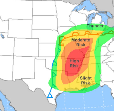
Here is my early map for Thursday/Thursday night's severe weather outbreak. Here is what will happen:
-The same low pressure that will give TX/OK severe weather tomorrow will eject NE. By late Thursday afternoon it will be over NW Missouri. This low pressure will have a vigorous low level jet with it which will cause very high amounts of wind shear, especially from Louisiana northward to as far north as Chicago. So if storms get going very strong winds and tornadoes are immediately threats. So the question is, where will the storms fire?
-I think the most intense storms, with the best threat for rotating super-cells will be from southern IL/NW Missouri south through Arkansas and even into northern Louisiana. These areas will have similar amounts of low level jet stream energy to work with, and much more heat and humidity, so storms will fire in those areas first and will be surface based, which favors tornadoes.
-Farther north there will be just as much wind shear/low level jet stream energy. So why only slight/moderate risks? Clouds/less heat/less moisture. That will slightly inhibit strong, individual, tornado producing super cells from developing as fast and as frequently. But, it should be known that in the slight/moderate risks area to the north of the high risk area any individual storms that do develop could rotate and easily produce tornadoes, I just don't think TOO many will do that.
-Along the cold front there will likely be a strong squall line. This will affect the slight/moderate risk areas, and even the high risk area. However, with the squall line the threat will be mainly high winds, and not many tornadoes. I think the squall line will develop farther north due to the forcing/added lift the front itself provides. I just don't think too many super cells will develop ahead of the squall line in the northern portions of the severe threat area.
-Along the warm front there may be some convection with a bit of a hail threat.
-Summary: Super cell thunderstorms will develop ahead of a cold front starting Thursday afternoon. They will be more potent and more widespread S.Illinois/central Missouri points south due to more warmth and humidity. Any individual storms that develop farther north could still spawn tornadoes. Along the cold front a squall line will develop and produce a damaging wind threat as far north as N.Missouri/N.Illinois. Along the warm front some storms that produce hail are also possible.
-I will have Friday's severe weather map later this evening.
No comments:
Post a Comment