Friday, May 30, 2008
Saturday: Severe Shifts Into the Northeast
Before my discussion, here is what the numbers on the map mean. The %'s are the chances of severe weather occurring within 25 miles of any given point. That means if you pick a point, that is the probability that severe weather will occur within 25 miles of it. Here is my discussion:
A cold front will continue to push south, now into the Northeast, southern Planes, and the Ohio Valley. Instability will be growing south of it, and moisture will be plentiful. The question is, where will the best instability be and best wind shear will be. I believe that from the Ohio river and points SW along the front, instability will be pretty high with CAPEs of 1500-2500. LIs will also be below -5 in that area. So in the risk zones from the Ohio river points SW, hail and locally damaging winds will be possible with any of the stronger storms. Wind shear will not be that high here so tornadoes are not a big threat. In the Northeast/Mid Atlantic, the set up is a little more complicated with questions to where the extensive cloud cover will be and where the best shear will be. I believe that most of the NE, from central PA/central NJ northward will have mostly cloudy skies most of the day from tonight's leftovers. This will really limit instability. However, south of that area, there will be more sun, dew points will be in the upper 60s, which will allow CAPEs of up to 2000, and LIs of as low as -6. These numbers will allow storms to bubble up in the moderate risk area, and with the wind shear damaging winds and tornadoes, along with large hail are all threats in this area. I believe that the storms will fire along the cold front in mid Afternoon, and become severe fairly quickly. These storms will fire in SE PA, MD, and western VA and move ENE quickly. There could very well be an organized line of storms along the cold front with discrete super cellular storms ahead of it. Farther north, instability will be lower, so the severe threat will be lower. If those areas can get some sun in the afternoon, scattered storms will develop along the front, but moisture will be a little lower, instability will be lower, and shear will be slightly lower, so farther north the severe threat is there but not as high as the mid Atlantic.
Severe Outbreak Getting Going
A tornado watch has been issued from MO-IL-IN. Storms are already firing in it, and will likely grow in size and strength this evening. Tornadoes are a big threat, along with damaging winds, and hail. As I have been saying the storms will be more super-cellular in nature early in the evening, but by late evening will organize into a complex of storms that will rapidly move east overnight with a damaging wind threat.
If You Are in a Severe Risk Area Today...
Another large severe weather outbreak is expected today. If you live in an area outlined in my previous post, of by your local weathermen keep your eyes to the sky late this afternoon and this evening. You can also check the warning box on the right side of my blog or your local news stations to see if severe weather is moving your way. I will not be able to update around 4, but stay safe until then.
Thursday, May 29, 2008
More Severe WX Expected Friday/Friday Night
On Friday/Friday night another major severe weather outbreak is expected in parts of the upper Mississippi Valley, lower Great Lakes, and parts of the Ohio valley. Here is what I expect to happen:
Tomorrow destabilization will occur in the warm sector south of a cold front. CAPEs will be 2000+ (good for severe), LIs will be -6 to -10 (good severe) and wind shear will be high. This will allow storms to explode in northern MO, SE IA, IL, southern WI, and western IN. With high wind shear and instability huge hail, damaging winds, and tornadoes will all be big threats. Tomorrow late afternoon/early evening as the storms are just initializing, super cells are very possible, especially in the moderate risk with tornadoes. Tomorrow evening, the storms will organize into a MCS over IL/IN, and rapidly move east through extreme southern Michigan, Ohio, and into PA with a damaging wind and flood threat as it goes along, due to the strong low level jet. Tomorrow night the MCS will weaken some as it moves into an area of much less instability. The severe threat will persist in the Ohio Valley/NE/Mid Atlantic Saturday.
FYI: My next post will be Friday around 4, analyzing tomorrows outbreak, and forecasting Saturday's outbreak.
Parts of northern KS (Glen Elder area) may have just gotten hit by a strong tornado. Unfortunetly I will not be able to look into this more until Friday afternoon.
Alma Named in East Pacific Late Last Night
Last night the organized area of low pressure in the eastern Pacific was named TD 1, and quickly become TS Alma. It is moving into Central America now, and will likely become disorganized over land. It will likely not move back out into the East Pac over the next few days. Flooding and gusty winds are likely over Central America as it slowly moves to the N and then NW.
As Expected, Severe WX Outbreak Ongoing, HIGH Risk Even Issued
A large severe weather outbreak is ongoing in the central Planes, and with extreme instability and wind shear lots of storms are quickly developing, and a lot of them are trying to drop tornadoes. This will continue this evening. Here is my forecast:
The organized clusters of super cell thunderstorms in northern KS, eastern NB, and getting into parts of west IA will continue to bring a tornado threat, especially with newly developing storms. Some strong tornadoes are still possible through the evening. However, as time goes on the storms will organize into a complex of severe storms, or a Mesoscale Convective System (MCS). This will rapidly move ENE throughout the night, through IA, southern MN, northern MO, and into IL and WI. It will pose a damaging wind and flooding rain threat throughout the night. With the strong moist southerly flow persisting over the Planes from the Gulf, storms will continue back building over night, so parts of KS, MO, and southern IA, and SW NB could see hours of heavy rain along with a severe threat over night, as the storms continue to train. I will have tomorrow's outlook soon.
Wednesday, May 28, 2008
Friday/Friday Night: Special Advanced Release Map
Here is my Friday-Friday night severe weather outlook. This is still a couple days away, but here is my best guess as to what will happen: The morning MCS will affect MI/northern PA/NY. This will limit instability in these areas due to the cloud cover and rain it will bring with it. However, south of those areas, and behind the cold front, in IN, IL, southern WI, MI, and IA should see some sun and moisture will be building throughout the day. This will allow instability to increase with CAPE values in a lot of areas of 2000+ (favorable for severe), and LIs of less than -6 (favorable for severe). This will let scattered storms explode in those areas (western 2/3 of moderate risk). This, along with the strong wind shear will cause an enhanced damaging wind and tornado threat, and the high instability will also cause a large hail threat on Friday. Late Friday afternoon/early evening, as the storms are initializing in the areas mentioned above super cellular storms are possible, especially as the storms are initializing. The storms will rapidly start moving east due to the fast flow aloft, and organize into a MCS during the evening over eastern IL/eastern WI/NW MI, and rapidly race east with a pronounced damaging wind threat and flood threat, especially due to the strong southerly flow in the lower levels, which will enhance the wind threat and bring up plenty of moisture to allow for heavy rains. Late evening into the overnight the MCS will race east through eastern IN and Ohio. By late Friday night the MCS should move into PA. Instability will be marginal but a 850MB (5,000 feet above sea level) jet will be roaring at 60 knots out of the SSW should allow the storms to continue with a heavy rain and damaging wind threat much of the night through PA. By Saturday morning the MCS should be approaching the Mid Atlantic and Southern New England. It should begin to weaken by then as it will be moving into even more stable air and the low level jet will weaken some.
FYI: I am not happy about this but I will not be able to get on my computer until late tomorrow, but at 8-830pm Thursday I will post my normal daily forecasts. Stay tuned for that, and feel free to reaf Thursday's forecasts below.
Thursday/Thursday Night Severe
A low pressure will be developing in the western Planes tomorrow, bring heat and humidity northward and strengthening the upper level winds, which will increase wind shear. Down in west TX, OK, and eastern NM, and SE CO a dry line will be the focal point of isolated storms tomorrow. Wind shear will be high enough so some severe storms, with tornadoes will be a threat along that dry line. Farther north, heat, humidity will be building all day, which will allow instability to also get high. Also, wind shear will be increasing in the western Planes. So, late tomorrow evening instability will be very high and things will likely explode in SE SD, eastern NB, western IA, and SW MN. Wind shear will also really be increasing tomorrow evening, so I believe that the areas mentioned above (the moderate risk zone) will see widespread storms developing by early evening tomorrow, with large hail, an enhanced damaging wind potential, and an enhanced tornado potential will exist with the storms, as wind shear will be high and instability will be very high. Late in the evening, the storms (which may be super cellular early in the evening) will likely organize into a complex of severe storms, or a Mesoscale Convective System (MCS). Once the storms organize into an MCS high winds will be the biggest threat along with flooding. The MCS will race east overnight, likely getting into Michigan by Friday morning.
Thursday Forecast
Mild weather will dominate the northeast. It will be cool to start with more frosts/freezes in the interior, but it will rebound nicely to near normal conditions by afternoon with mostly sunny skies. Day 1 of a 3 day severe weather outbreak will take place tomorrow in the Planes, with a storm threat along with warm and humid conditions. The NW will chill down a bit with a north flow developing behind this system, with some rain also possible in the NW. Tomorrow's severe map will be out by 7-730PM EDT.
Tropical Development in Caribbean or Eastern Pacific?
An area of low pressure has developed just off the Central America coast in the Eastern Pacific. Right now, it is just drifting around and not going anywhere. Right now, it is near land and not in a faverable spot to develop into anything named. It is expected to remain that way for a while. Now, will this low head into the Atlantic side of Central America and perhaps threaten the US? I dought it. There is a lot of ridging over the Gulf of Mexico and the southern US, so this should keep this system out of the Atlantic. However, in 8-10 days the ridging will weaken and the pattern will remain favorable for the possibility of another low spinning up near Central America, so in 10-14+ days we may need to monitor for another possible tropical system near the US or Mexico. So, to sum it all up, here is my forecast: An area of low pressure has spun up near Central America over the Eastern Pacific. This low is drifting around, and is expected to continue to drift N-NW over the next few days. Wind shear is low enough for tropical development, and water temps are warm enough, but this system will remain close to Central America and Mexico, so there is less than a 25% chance in my opinion of a named storm coming out of this. Even though this low may not be named, its close proximaty to land and slow movement will cause possibly deadly flooding over Central America and eventually Mexico. Down the road (10-14+days out) another low may spin up near Central America, and may eventually threaten the US. I will have a more detailed look at tomorrow's severe by 6-630PM EDT.
Tuesday, May 27, 2008
Preview of Late Week Severe Storms
For now this is just a brief preview, but later this week, Thursday-Sunday there could be a major severe weather outbreak, with tornadoes being a threat. I posted the GFS forecast for Thursday evening, showing some activity in the Planes. I also posted the SPC outlooks for this time period, and large areas are outlined, especially for Friday-Saturday. Now, what the setup is going to be: Late Thursday, a low pressure will develop in the southern Planes, and move NE towards the southern Great Lakes by later Friday, then through New England on Saturday. Now, there will be plenty of instability south of the low, and there will be high amounts of wind shear in the warm sector as the low tracks NE. This could spark severe weather all along the track of this low. I will have more details on this over the next couple days, as if this pans out we could see another significant severe weather outbreak.
FYI: I will not be able to update this blog until about 4PM on Wednesday. But I will go into more detail about the late week severe weather outbreak, update the forecasts for Thursday, and cover any more breaking weather news. Still feel free to read the posts below for forecasts for Wednesday, a brief look at the late week severe weather outbreak, and info on the weekend tornadoes. The Parkersburg tornado was rated an EF5 (see that post below).
Wednesday/Wednesday Night Severe
Here is my severe weather outlook for tomorrow and tomorrow night. The cold front that slid through the NE/Mid Atlantic today will still be affecting the deep south. There won't be much wind shear with this, but there will be plenty of moisture and high instability, which should lead to scattered to widespread storms tomorrow in the deep south, with a hail/high wind threat with the stronger storms. The tornado threat will be low, except for in TX/NM. An area of low pressure will begin to organize in that region late tomorrow, so wind shear may pick up some in that area, adding a small tornado threat. Other then that I believe that the TX/OK/NM area will see scattered storms developing tomorrow, with a hail/damaging wind threat in the stronger storms.
I need to step away from the computer for a bit, but over the next hour or so expect a post previewing the severe weather outbreak(?) that may occur later this week into the weekend, and if I have time I will detail the possibility of a tropical system developing within the next few days in the Caribbean.
Wednesday Forecast
Here is a look at Wednesday's forecast. In the Great Lakes/Northeast, it will be a very chilly start in the wake of a cold front. Frosts/freezes are possible, so if you happen to be under a frost advisory/freeze warning, heed it and cover up any tender vegetation. In the areas behind the front tomorrow, it will recover some in the afternoon under partly to mostly sunny skies, but highs tomorrow will be 5-15 degrees below normal behind the front. The same front will bring more showers/storms to the south, along with warm and humid conditions south of the front also. The west will continue to warm, but in the Pac NW there will be a west wind, which could bring some showers to the NW, and with some cooler air aloft there could even be some thunder in the afternoon there. I will have the severe wx forecast for tomorrow by 10:10PM EDT.
Current Severe WX Situation
We have a couple areas of severe concern this evening, western TX/maybe SE OK, and parts of the NE/Mid Atlantic.
Western TX/SE OK: As I said yesterday there is plenty of moisture and instability in this area, which is fueling storms, with large hail and damaging winds. However, wind shear is rather weak in this area so as I said yesterday just a very small tornado threat in this area. So, this evening scattered to at times widespread storms will continue in the same general area they are in now, perhaps spreading east-southeast a bit. The threats will continue to be large hail, damaging winds, isolated flooding, and maybe a renegade tornado. The storms will continue through this evening, but will slowly diminish later tonight.
Southern Northeast/Mid Atlantic: A cold front is sliding south through the area. As I said last night instability is marginal and wind shear is very low. But, with a strong cold front coming through storms have fired along the front this afternoon, with heavy rains, gusty winds, and dangerous lightning. But, severe weather with the front in the NE/Mid Atlantic has been very limited up to this point, and is expected to remain very limited this evening. The storms will continue to push SE tonight as the front pushes south, but should really weaken after sun down.
I will update tomorrow's forecasts soon.
Monday, May 26, 2008
Check Back Tomorrow Evening
Unfortunetly I will be away from my computer until 8 Tuesday evening, so I will not be able to post until then. Still, feel free to read the posts below. There is a wealth of links to important information, stories, pictures, ect of Sunday's deadly tornado outbreak. There are also forecasts for Tuesday. Tuesday evening I do expect to post:
1. Any new info about Sunday's deadly tornadoes
2. The forecasts for Wednesday
3. Preview the possible outbreak this weekend
4. If I have time, I will preview the possible tropical system later this week. That's right, it's that time of year again!
1. Any new info about Sunday's deadly tornadoes
2. The forecasts for Wednesday
3. Preview the possible outbreak this weekend
4. If I have time, I will preview the possible tropical system later this week. That's right, it's that time of year again!
Tuesday/Tuesday Night Severe
Well, tomorrow looks like things will really calm down tomorrow severe weather wise. We have some areas where there is a small risk of severe weather. In the northeast, there will be a cold front coming southward. To me, this really looks non-impressive severe wise for the NE. That slight risk is a very low end slight risk in my opinion. Instability tomorrow will be OK, with some peaks of sun expected, and moisture will be OK with dew points in the lower to maybe middle 60s. So, with the front coming through in the afternoon some showers and storms will develop, but I do not think many of them will get severe. Again, instablity will be OK, but not great, and there will really be no wind shear in the Northeast tomorrow. So, maybe some small hail and gusty downdraft winds with the strongest storms in the northeast tomorrow. In the south, a wave of low pressure will be riding along the same cold front. However, things in the south are also not great for severe weather. There will be almost no wind shear, however, moisture and instability will be plentiful in the southern Mississippi Valley area slight risk. So, I think that scattered showers/storms will develop in that area in the afternoon, with hail and isolated damaging winds in the stronger storms in the south. So tomorrow, everyone will get a chance to catch there breath with really no threat for tornadoes anywhere in the continental US.
Tuesday Forecast
Here is a quick look at tomorrow's forecast. A cold front will be moving through the NE/Mid Atlantic, and some strong storms could develop. Another wave of low pressure, the one bringing severe weather tonight to the southern Planes will move east, sparking some more rainy/stormy conditions. Some storms in the deep south could get strong tomorrow afternoon but it will not get out of control. The west will remain a little bit unstable so some showers are possible, but it will be getting a little warmer in the west.
Severe Weather Ongoing in OK, KS, TX, and AR
We have quite a few severe thunderstorms in the southern Planes this evening. There have been several tornado warnings but so far none of the storms have looked like they have produced severe damage, although the one that is now near Ponka/Newkirk, OK at the moment looks like it may as it looks impressive on radar and is moving through populated areas. More on that later if anything comes out of it. So, you can see above where the storms are now, and where the watches and warning are. But where will the storms threaten later this evening and tonight? Well, it looks like over the next 2-4 hours, there will be isolated storms in SW TX with a hail, wind and tornado threat due to a dry line in that area. Now, in far north TX, western and northern OK, and south/central Kansas is the big threat zone. Wind shear is much high in that area, and that area has more moisture and is more unstable. So, widespread storms will continue to affect that area, with all modes of severe, including the chance of some strong tornadoes will be possible in that area. Later this evening, as the storms become more organized and jet stream energy continues to strengthen, these storms will organize into a complex of storms or a Mesoscale Convective System (MCS). This will move ESE through SE Kansas, eastern OK, and maybe skirting far northern TX. This complex of storms may also end up in far SE MO/western AR later tonight. These storms will bring a tornado threat through the evening, but as the night goes on the threat with these storms will transform into more of a damaging wind threat. Flooding is also possible with this complex of storms. Of less concern is an area of storms in AR along an old outflow boundary. Wind shear is not that high, but with very high instability some hail/strong winds are possible with any storms. These storms should slowly dissipate late this evening. There is also a cold front moving through the lower GLs/NW New England. Some storms are trying to fire but the severe threat along this front this evening remains rather low.
Coon Rapids, MN Tornado an EF1...Hugo, MN Tornado and EF3
The preliminary damage survey is done in the Twin Cities area, and it appears that there were two tornadoes spawned from the same storm north of the Twin Cities. The first tornado affected the Coon Rapids area. Here is part of the NWS statement regaurding the tornado: "THE FIRST TORNADO TOUCHED DOWN IN COON RAPIDS AND LIFTED IN THE WESTERN SECTIONS OF BLAINE. THIS TORNADO PRODUCED EF1 DAMAGE...LIKELY CAUSED BY WINDS BETWEEN 86 AND 110 MPH." The second tornado was longer tracked, stronger, and was the one that took the life of a 2 year old toddler. This was the Hugo, MN tornado. Here is part of the the NWS regarding this tornado: "THE SECOND...AND MOST DAMAGING...TORNADO TOUCHED DOWN ON THE EASTERN
SIDE OF LINO LAKES...CONTINUING THROUGH THE COMMUNITY OF HUGO. THIS TORNADO PRODUCED EF3 DAMAGE...LIKELY RESULTING FROM TORNADIC WINDS IN THE 136 TO 165 MPH RANGE. THE SURVEY TEAM HAS NOT YET DETERMINED WHERE THIS SECOND TORNADO TERMINATED...AND FURTHER INVESTIGATION OF DAMAGE REPORTS IN WESTERN WISCONSIN WILL BE UNDERTAKEN TOMORROW...TO DETERMINE WHETHER THE TORNADO CONTINUED INTO THAT AREA." Again, if there is any more new info tomorrow I will post it here.
Storms in KS, OK, NW TX Only to Get Worse This Evening
A piece of energy will ride along the cold front this evening, sparking more severe storms in TX, OK, and KS. There is a growing amount of wind shear, so severe weather is very possible in the areas outlined above. I expect large hail, damaging winds, and yes, even the threat of more possibly destructive tornadoes this evening, especially in the red shaded area.
PS: Sorry about not posting this sooner and not being more detailed in my discussion, but I have been busy today still posting info on yesterdays deadly twisters and have just been busy otherwise with family/friends/what not on this holiday.
Prelimanry Rating For Parkersburg Tornado: EF3+
"A tattered American flag sits atop a mound of debris at a destroyed convenience store in Parkersburg, Iowa, on Monday, May 26, 2008, a day after a tornado struck the town.(AP Photo/Kevin Sanders)"
A preliminary survey from the NWS in Des Moines, IA concluded that the tornado that affected the Parkersburg, IA area was at least an EF3 on the Enhanced Fujita scale, possibly higher. The tornado's path was 43 miles long and up to 1.2 miles wide. Prilimanry fatalities stand at 7, preliminary injuries stand at around 70. At the end of the NWS preliminary statement it said: "ADDITIONAL DETAIL WILL BE ADDED TO THIS REPORT ON TUESDAY ALONG WITH FINAL EF SCALE RATING RESULTS." So, that basically means that tomorrow we will know the exact details regarding track and strength.
I found the AP slide show of storm damage from the Parkersburg IA, and Hugo, MN area tornadoes, and the pictures are truly devastating. You can view all 50+ pictures at this location:
Total Stats So Far From This 4 Day Outbreak
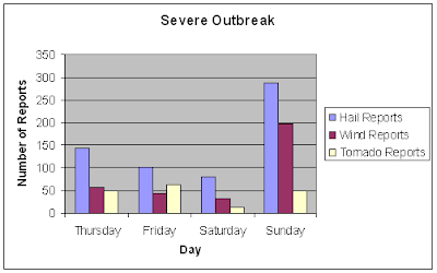
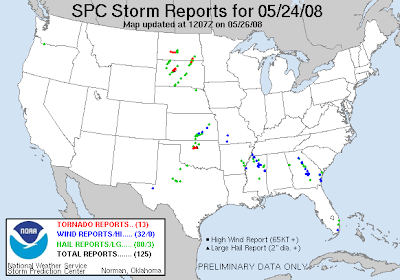
The outbreak still is on-going, with a severe threat still for today/tonight, but how has it added up so far? Well, so far there have been four pretty active days, with yesterday by far having the most severe reports. So far, since Thursday we have had 172 tornado reports and 952 wind/hail reports (not including today). So, this has been a widespread, long lived severe weather outbreak that has brought thousands of severe reports. I will update these stats later this week after this outbreak concludes (we have to get through tomorrow first).
Some More Info on Hugo, MN Tornado
Here is a link to some areal coverage of the Hugo tornado (near the Twin Cities). Some houses were heavily damaged. One death has been confirmed from this tornado. Unfortunately it was a two year old toddler.
This story I posted last night in its entirety, but it has been updated. According to the story about 50 homes have been destroyed in Hugo, MN.
Before barreling through Hugo, MN, the storm brought a tornado to the Coon, MN area. Two people were injured.
Here is a video report from that site:
Here is another article. According to the article, one death has occurred and 8 injuries have been reported because of the tornado. It is estimated that at least 50 homes were destroyed and another 100 were seriously damaged. Read the whole article below. There is also a link to a photo gallery on this site:
Here is the story from the Fox station in the Twin Cities. It has information including damage statistics, and links to photo galleries from the storm.
http://www.myfoxtwincities.com/myfox/pages/Home/Detail?contentId=6625596&version=3&locale=EN-US&layoutCode=TSTY&pageId=1.1.1
Here is a related story from the Associated Press:
http://www.thedickinsonpress.com/ap/index.cfm?page=view&id=D90T084O3
The storm also reported gulf ball-baseball sized hail and damaging straight line winds along with the tornadoes.
More Details Come Out About Parkersburg, IA Tornado
AP Photo/Kevin Sanders
The above picture is what is left of a house in Parkersburg. Nothing left, just a foundation. You can't even tell where the rest of the house is. There isn't even a pile of debris. The tornado was just that strong.
The above picture is from a home video shot as the tornado approached Parkersburg, Iowa yesterday evening. The full story and video can be read and watched by clicking the below line. But, the story says that as of this morning "A tornado killed seven people and injured at least 50 others as it pushed through the town of Parkersburg near Cedar Falls Sunday night.
Five of the deaths were in the town of Parkersburg and two were in New Hartford. Unfortunately it says "officials are still searching damaged properties, and that the death toll and injury numbers could climb." So, it does not look good out of the Parkersburg area this morning. From everything I have looked at, it unfortunately appears that the southern half of town was wiped out, which is just terrible. Again the link immediately below this text is to the whole story and video of the tornado and damage.
The next link is to some very revealing areal shots taken by a chopper yesterday evening over Parkersburg. It shows that this tornado was truly devastating.
Here is the related story from the news station that had the chopper shots in the link above:
The next link below has another video showing the extreme damage, and has another related story, including a couple of witness accounts of what happened.
This next story is a bit brief, but it shows that this tornado was fairly long tracked, and that the damage was not limited to Parkersburg. It also has a few damage pics.
This next story goes into detail about the damage near Dunkerton, IA. That city was hit by a deadly tornado back in 2000. There are also some damage pics and a link to a video report in the upper left corner.
Here is a video report out of North Waterloo, IA.
Here is a detailed story from the Associated Press, along with a few damage photos:
Here is another detailed story. I posted it in its entirty yesterday evening, but it has been updated and is now much more detailed.
This storm not only produced large, damaging tornadoes, but there was also a 93MPH straight line wind gust measured at the Waterloo Airport, and softball-grapefruit sized hail was also reported with this storm.
Sunday, May 25, 2008
Chicago Under the gun Tonight?
It could get interesting in Chicago in a couple of hours:
There is a small bow echo rapidly moving ESE across northern IL, with a damaging wind threat. If it continues on its current corse and holds together Chicago could see some severe weather in a couple of hours. However, bow echos like this sometimes dive toward the south, so the brunt of the severe may be just south of Chicago. There is another batch of t-storms in central IA that is moving ENE, which may impact eastern IA, NE MO, and central IL over the next few hours. High winds are also the biggest threat there.
So, if I lived in or near Chicago, what would I do? Keep my weather radio ready, and be ready to act if any warnings come in in the middle of the night.
Monday/Monday Night Severe
The same system will bring severe weather to the same areas tomorrow, just shifted a little farther southeast. The biggest area of concern is in Kansas, where a little stronger jet streak will move through tomorrow evening. If storms can fire, which is likely in that area there could be some significant severe weather once again. In Texas, there will again be a severe threat along a dry line. There will also be a severe threat along the same cold front that brough tons of severe today from Missouri into southern Michigan, but tomorrow will be different than today. There will be clouds to limit instablity some, and not nearly as much shear as today. This will keep the severe threat relativly small, however if some sun breaks out there will be scattered storms, some of which severe developing tomorrow afternoon along the cold front. Hail, high winds, and isolated tornadoes will all be threats. On a side note, I would not be surprised to see some high winds, or even a tornado or two in upstate New York, with the same jet max that brough all the severe weather today moving across that area. But, due to limited instablity it would not get out of hand like it did today.
Memorial Day Forecast
It has been a very active weekend, with lots of severe weather in the central US. For the holiday, is looks like that will continue, with severe weather possible from parts of NY back to Texas. It could rain on a lot of people's parades tomorrow, with at least a 30% chance of rain for much of the nation (anywhere colored is a 30%+ chance of rain). It will be warm in the south, Mid Atlantic, and Northeast, but cooler in the upper Great Lakes and Midwest behind a cold front. The southwest will warm some but it will not get too hot. The Rockies will remain cool with a chance of showers, and the northwest will also warm a little to seasonable conditions with only small rain chances.
Some Links for the Twin Cities Area Tornadoes
http://wcco.com/
http://www.kstp.com/
http://www.kare11.com/
http://www.channel4000.com/index.html
http://www.myfoxtwincities.com/myfox/
http://www.startribune.com/local/19246464.html?location_refer=Taste
http://www.thedickinsonpress.com/ap/index.cfm?page=view&id=D90T084O3
http://www.kxmb.com/News/241809.asp
http://ap.google.com/article/ALeqM5jW-BndswWuhgPAPXOK4Q6TCQsANQD90T03E00
Some Links to Info on Waterloo, IA Area Tornadoes
I do not want to be posting each story in its full context as they come out so, here are some links:
http://www.wcfcourier.com/articles/2008/05/25/news/top_story/doc4839f26069e5c347098257.txt
http://www.desmoinesregister.com/apps/pbcs.dll/article?AID=/20080525/NEWS/80525003/-1/BUSINESS04
http://www.gazetteonline.com/apps/pbcs.dll/article?AID=/20080525/NEWS/326681311/1006
http://www.kcci.com/news/16391215/detail.html
http://www.kcrg.com/
http://www.kcrg.com/news/streaming/10476432.html?video=pop&t=a (streaming live, for now)
http://www.kwwl.com/
http://www.kimt.com/news/local/19250124.html
Damage Reports Out of Parkersburg Don't Look Good
I have been searching and Google News finally showed a story out of Parkersburg, IA. It does not look good. Unfortunetly no pictures accompany story but the article below does paint a pretty desestaiting image. Story below:
"Tornado takes out Parkersburg high school
A tornado about a mile wide left behind extensive damage, injuries and possible fatalities in northeast Iowa early this evening, officials said.The tornado ripped off the roof of the high school in Parkersburg and took out sections of the building, said Superintendent Jon Thompson.The high school will never be used again, he said.Houses to the south of the high school were also flattened, Thompson said.The parking lot at the high school was turned into a triage center, and district officials this evening opened up the middle school in Aplington and an elementary school in Parkersburg as shelters.The tornado moved between 5:30 and 6:15 p.m. from Aplington to New Hartford to the north side of Waterloo and then into Dunkerton, according to Miles Schumacher, a meteorologist with the National Weather Service.Schumacher said more than one tornado probably touched down, but most of the damage was caused by the mile-wide tornado.The Waterloo airport reported wind speeds of 93 mph, Schumacher said.This storm system caused the most damage in Iowa so far this year. Tornadoes hit southern Iowa on April 10, causing damage but no injuries.Gary Frank, an elder at First Congregational church in Parkersburg also offered up shelter.“You can’t even tell anything has happened here, but just two blocks up the street its total devastation,” he said.The major damage occurred on the south side of the town’s main strip, Frank said. Downed power lines, roofless buildings and emergency vehicles filled the street this evening while residents remained inside. “I think people are still in a state of shock,” he said.Power lines have also been knocked down in the area, leaving many residents without power.This evening, Iowa State Patrol troopers are blocking the entrances to Parkersburg.A dispatcher with the Butler County sheriff’s department said authorities were investigating damage to a grain elevator that may have caused an anhydrous ammonia leak.
The Associated Press contributed to this article."
Source: http://www.desmoinesregister.com/apps/pbcs.dll/article?AID=/20080525/NEWS/80525003/-1/SPORTS0806
A Quick Forecast For the Rest of Tonight's Severe Weather
STORMS IN WISCONSIN, AND STORMS IN IOWA HAVE BOTH DEVELOPED INTO MESOSCALE CONVECTIVE COMPLEXES. THEY WILL CONTINUE TO CHARGE EAST WITH HIGH WIND THREAT, AND POSSIBLE TORNADO THREAT AS WELL.
The super cells that have and still are producing tornadoes across Minnesota and Iowa are developing into big complexes of storms, which could produce straight line wind damage. The complex that is now over north-central Wisconsin will charge east to maybe a little south of east over the next couple of hours. It will weaken as we loose day time heating and as the storms reach lake Michigan. The other complex of storms, in NE Iowa, NW IL, and far southern WI will continue to slide ESE, and the storms will continue to back build and train through the rest of the evening. This will bring a continued severe threats the areas I mentioned above, and increase a flooding threat. Due to very high wind shear there will be a high damaging wind threat for the next several hours, and also a tornado threat for the next couple of hours. This complex of storms has had a history of producing devastating tornadoes. I think this complex will bring some storms to Chicago. Will they hold together and still be severe? That is definitely a possibility. There is another area of storms, possibly tornadic at times in southern IL, eastern MO, and northern AR associated with a MCV. These will continue to drift ENE, with high winds, hail, tornadoes and flooding rains continuing to be threats as the night goes on. There is another MCS in Kansas along the cold front, which will bring a high wind, hail, and flooding threat as it moves east into Missouri, eastern KS, and even SW Iowa. There is another line of storms in the Texas Panhandle, along the dry line, with all modes of severe being possible. These should continue to be severe through around midnight, but after midnight the loss of day time heating should let these storms SLOWLY die down. Again, it has been such a busy evening, that is why I was not a little more detailed in my reasoning, and just said where I think these storms will go. I just don't have time, essentially. I am going to try to also squeeze in tomorrow's forecast within the next couple hours.
Another Deadly Tornado in Minnasota
These are just three of the pictures of the devestation in Hugo, MN, that was hit by a tornado on Sunday afternoon. More pictures can be seen by clicking on the slideshow link below.
Here is the story from WCCO in the Twin Cities: (link to the site I got it from below)
"2-Year-Old Killed, 20 Missing In Hugo Tornado
HUGO, Minn. (AP) ― A town official says a 2-year-old child has died and 20 are missing after a severe storm swept through a St. Paul suburb.Hugo Fire Chief Jim Compton says another child in critical condition and transported to Regions Hospital in St. Paul and another eight people were taken to area hospitals with injuries.Hugo City Administrator Mike Ericson says at least one dozen homes were destroyed and another three dozen damaged.Residents reported a tornado touching down in the area, but that has not been confirmed by the National Weather Service."It's horrible," Ericson said. "The citizens are very shook and scared."Dozens of emergency crews descended on the town to look for those who have not been located and assess the damage. About 15,500 customers in the northeast metro area were without power, Xcel Energy Company said.Hugo Public Works Director Chris Petree said his family took shelter in the basement before the storm lifted his house off the ground and completely wiped out the second floor of the home."I put my daughter down first, my wife on top of her and then I bear-hugged on top of them," Petree said.The storm system started northwest of the Twin Cities and quickly spread across the north metro area from Albertville through Coon Rapids and Hugo to the northeast. The National Weather Service confirmed a tornado touched down in Coon Rapids, downing power lines and uprooting trees.Earlier in the afternoon, the most damaging effects of the storm system came from large hail, ranging from nickel-sized to baseball-sized as it pelted Monticello, Maple Lake and Albertville, where some windows in houses and car windshields were shattered.Almost 800 were powerless in the St. Cloud-Monticello area as well, Xcel said.Hugo appeared to be the hardest hit, with residents saying a tornado touched down near the city's downtown late Sunday afternoon. They reported large hail, high winds and torrential rains as the system blew through the town.As he huddled in his basement against a foundation wall with his wife and 2 1/2-year-old daughter, Petree said they heard the thunderous sound of their house coming off the ground."All you hear is glass breaking and wood tearing and breaking in half," Petree said.A tornado watch means conditions are favorable for tornadoes and severe thunderstorms.Several counties are under the watch. They include Anoka, Blue Earth, Brown, Carver, Chisago, Dakota, Dodge, Faribault, Fillmore, Freeborn, Goodhue, Hennepin, Houston, Isanti, Kandiyohi, LeSueur, Martin, McLeod, Meeker, Mower, Nicollet, Olmsted, ramsey, Renville, Rice, Scott, Sherburne, Sibley, Steele, Wabasha, Waseca, Washington, Watonwan, Winona and Wright counties."
Waterloo, IA Area Hammered
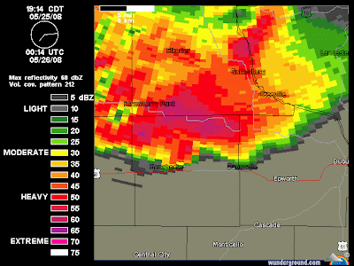
This evening I have been tracking a long track, large, and destructive tornado that touched down near Parkersburg, IA, tracked just north of Waterloo, near or over Oelwien, Dunkertown, Cedar Falls, Fairbank, near or over Strawberry Point, near or over Hazeltown, near or over New Hartford, near or over Manchester, and now as of this writing Dyrsville has just got hammered, and now the possible tornado is coming close to Debuque, IA. (Pardon any misspellings of city names) There have been other tornadoes times near the main tornado, and other smaller communities not mentioned above have been impacted. There has been heavy damage reported all along the path of this storm, with the heaviest damage reported in Parkersburg, IA where "you can't tell that homes were ever there" in parts of the town. As of around 8:30PM there have been a lot of injury reports and so far one un-confirmed fatality. I will update this later.
Subscribe to:
Posts (Atom)